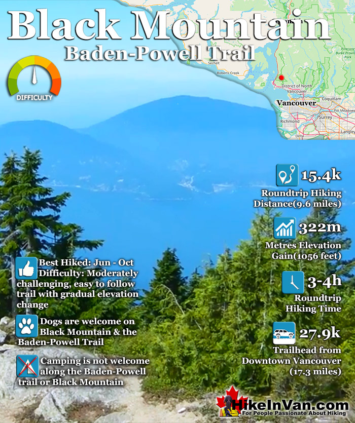
![]() Black Mountain can be reached from two different trailheads. The trailhead from Cypress Resort and the original trail off Marine Drive halfway between Horseshoe Bay and Lighthouse Park. The trailhead south of Horseshoe Bay is a challenging 19 kilometre roundtrip hike but fantastically scenic. This route follows the Trans Canada Trail for about 20 minutes before branching off toward, then past Whyte Lake.
Black Mountain can be reached from two different trailheads. The trailhead from Cypress Resort and the original trail off Marine Drive halfway between Horseshoe Bay and Lighthouse Park. The trailhead south of Horseshoe Bay is a challenging 19 kilometre roundtrip hike but fantastically scenic. This route follows the Trans Canada Trail for about 20 minutes before branching off toward, then past Whyte Lake.
 Cypress Mountain start is great
- Cypress has a pub/restaurant
- Nice trail in deep wilderness
- Amazing views of Howe Sound
- Dogs are welcome
- Lots of lakes for a swim
- Nicely varied terrain & sights
- Lots of route variations to hike
 Well known & often crowded
- Camping is not welcome
Vancouver Hiking Trails
![]() Black Mountain
Black Mountain ![]() Brunswick Mountain
Brunswick Mountain ![]() Burnaby Lake
Burnaby Lake ![]() Burnaby Mountain
Burnaby Mountain ![]() Coliseum Mountain
Coliseum Mountain ![]() Crown Mountain
Crown Mountain ![]() Cypress Falls
Cypress Falls ![]() Deeks Peak
Deeks Peak ![]() Deep Cove
Deep Cove ![]() Deer Lake
Deer Lake ![]() Dog Mountain
Dog Mountain ![]() Goat Mountain
Goat Mountain ![]() Goldie Lake
Goldie Lake ![]() Grouse
Grouse ![]() Hollyburn Mountain
Hollyburn Mountain ![]() Kitsilano Beaches
Kitsilano Beaches ![]() Lighthouse Park
Lighthouse Park ![]() Lynn Canyon
Lynn Canyon ![]() Lynn Peak
Lynn Peak ![]() Mt Elsay
Mt Elsay ![]() Mt Fromme
Mt Fromme ![]() Mt Hanover
Mt Hanover ![]() Mt Harvey
Mt Harvey ![]() Mt Seymour
Mt Seymour ![]() Mt Strachan
Mt Strachan ![]() Mystery Lake
Mystery Lake ![]() Pacific Spirit
Pacific Spirit ![]() Rice Lake
Rice Lake ![]() St Mark's
St Mark's ![]() Stanley Park
Stanley Park ![]() The Lions
The Lions ![]() Unnecessary
Unnecessary
The Cypress Mountain Resort is the nicer, shorter and easier way to access Black Mountain and Eagle Bluffs. Located just a short and very nice, 30 minute drive from downtown Vancouver, the Black Mountain and Eagle Bluffs trail begins next to the Cypress Mountain Resort chairlifts. The well marked trail branches away from the chairlift to the left and quickly ascends into the deep and beautiful forest. Follow the clear signs to Eagle Bluffs. The route can be done in a circle route, so try to take the other route on the way back for variety. Black Mountain is a short side trail off this circle route. Allow yourself 3-4 hours for the 7.7k return trip to both Black Mountain and Eagle Bluffs. The elevation gain is 350m in 4k. Expect to need snowshoes December to May. During these months use caution as snow may obscure the trail markers and combined with bad weather can very easily make you lose the trail. The Cypress Mountain trailhead and parking for Black Mountain and Eagle Bluffs is also the gateway to the amazing Howe Sound Crest Trail. This amazing trail in Cypress Provincial Park extends north from the Cypress Resort parking and ascends deep into the North Shore mountains. Mount Strachan, St Mark's Summit, Unnecessary Mountain and The Lions are all accessible from this trailhead. Continuing north beyond The Lions, the Howe Sound Crest Trail leads to Mount Harvey, Mount Hanover, Brunswick Mountain and finally Deeks Peak. Hollyburn Mountain is another wonderful hiking trail near the Cypress Mountain, Black Mountain trailhead. Located at the Cypress Mountain cross country skiing area the trailhead to Hollyburn Mountain is marked with a large mapboard. Hollyburn Mountain is an easy, 7 kilometre roundtrip hike to fantastic views of Vancouver.
Black Mountain View of Mount Baker

Black Mountain Cypress Trailhead
The Eagle Bluffs and Black Mountain trailhead is very easy to find. It is found at Cypress Mountain Resort in West Vancouver (free parking and free to use the trails). From downtown Vancouver follow the signs across the Lions Gate Bridge as if you were going to Whistler on the Sea to Sky Highway. From Sea to Sky Highway #99 (aka Highway #1), about 10 minutes from the Lions Gate Bridge take the #8 Exit to Cypress Provincial Park. There are clear signs on the highway for this exit so you can't miss it. Follow Cypress Bowl Rd almost to Cypress Mountain Resort. Follow this road all the way to the end and park at the Cypress Mountain Resort Ski area. You will see a large wooden map board showing trails in the Cypress Mountain area. You will see on this board the trail leading to Eagle Bluff and Black Mountain. You will need to walk toward the nearby chairlift and follow the trail leading into the trees on the left side and clear trail markers and signs from there.
Black Mountain Trans Canada(Lower) Trailhead
From Vancouver take Exit 2 for Eagleridge Drive, then left on Marine Drive. Just past the marina, turn left on Cranley Drive. Look for the sign for the Trans Canada Trail about 500 metres from Marine Drive. From here follow the Trans Canada Trail signs that take you under the Highway. Continue following the Trans Canada Trail for about 20 minutes until you come to a junction. The Trans Canada Trail goes right, however, follow the trail going left and take the bridge where you follow Whyte Creek. Soon you will see Whyte Lake on your right, at the next fork in the trail, bear right and this will lead to the well marked trail to Eagle Bluffs and then Black Mountain.
Best Whistler & Garibaldi Park Hiking Trails!
Whistler & Garibaldi Park Hiking by Month!


Explore BC Hiking Destinations!

Whistler Hiking Trails

Squamish Hiking Trails

Vancouver Hiking Trails

Clayoquot Hiking Trails
Victoria Hiking Trails

