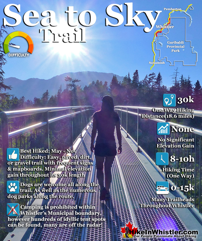
![]() The Sea to Sky Trail is a 180 kilometre multi-use trail that runs from Squamish to D'Arcy. The trail is still under construction in many parts, however, the amazing route through Whistler is finally in place. The Whistler section of the Sea to Sky Trail is 33 kilometres long between Brandywine Falls Provincial Park and WedgeWoods Estates just north of Green Lake, near the trailhead for Wedgemount Lake.
The Sea to Sky Trail is a 180 kilometre multi-use trail that runs from Squamish to D'Arcy. The trail is still under construction in many parts, however, the amazing route through Whistler is finally in place. The Whistler section of the Sea to Sky Trail is 33 kilometres long between Brandywine Falls Provincial Park and WedgeWoods Estates just north of Green Lake, near the trailhead for Wedgemount Lake.
 Clearly defined trail with clear directions
- Wonderful variety of views with lots of highlights
- Can be done in sections, all of them amazing
- Passes close to and along numerous lakes
- Crosses several beautiful bridges
- Family friendly & relaxing terrain
- Many access points with free parking
- Escape the crowds easily into deep forest!
 South of Brandywine is along the highway
- North of Wedge is along the highway
Whistler & Garibaldi Hiking
![]() Alexander Falls
Alexander Falls ![]() Ancient Cedars
Ancient Cedars ![]() Black Tusk
Black Tusk ![]() Blackcomb Mountain
Blackcomb Mountain ![]() Brandywine Falls
Brandywine Falls ![]() Brandywine Meadows
Brandywine Meadows ![]() Brew Lake
Brew Lake ![]() Callaghan Lake
Callaghan Lake ![]() Cheakamus Lake
Cheakamus Lake ![]() Cheakamus River
Cheakamus River ![]() Cirque Lake
Cirque Lake ![]() Flank Trail
Flank Trail ![]() Garibaldi Lake
Garibaldi Lake ![]() Garibaldi Park
Garibaldi Park ![]() Helm Creek
Helm Creek ![]() Jane Lakes
Jane Lakes ![]() Joffre Lakes
Joffre Lakes ![]() Keyhole Hot Springs
Keyhole Hot Springs ![]() Logger’s Lake
Logger’s Lake ![]() Madeley Lake
Madeley Lake ![]() Meager Hot Springs
Meager Hot Springs ![]() Nairn Falls
Nairn Falls ![]() Newt Lake
Newt Lake ![]() Panorama Ridge
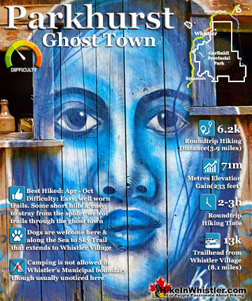
Panorama Ridge ![]() Parkhurst Ghost Town
Parkhurst Ghost Town ![]() Rainbow Falls
Rainbow Falls ![]() Rainbow Lake
Rainbow Lake ![]() Ring Lake
Ring Lake ![]() Russet Lake
Russet Lake ![]() Sea to Sky Trail
Sea to Sky Trail ![]() Skookumchuck Hot Springs
Skookumchuck Hot Springs ![]() Sloquet Hot Springs
Sloquet Hot Springs ![]() Sproatt East
Sproatt East ![]() Sproatt West
Sproatt West ![]() Taylor Meadows
Taylor Meadows ![]() Train Wreck
Train Wreck ![]() Wedgemount Lake
Wedgemount Lake ![]() Whistler Mountain
Whistler Mountain
![]() January
January ![]() February
February ![]() March
March ![]() April
April ![]() May
May ![]() June
June ![]() July
July ![]() August
August ![]() September
September ![]() October
October ![]() November
November ![]() December
December
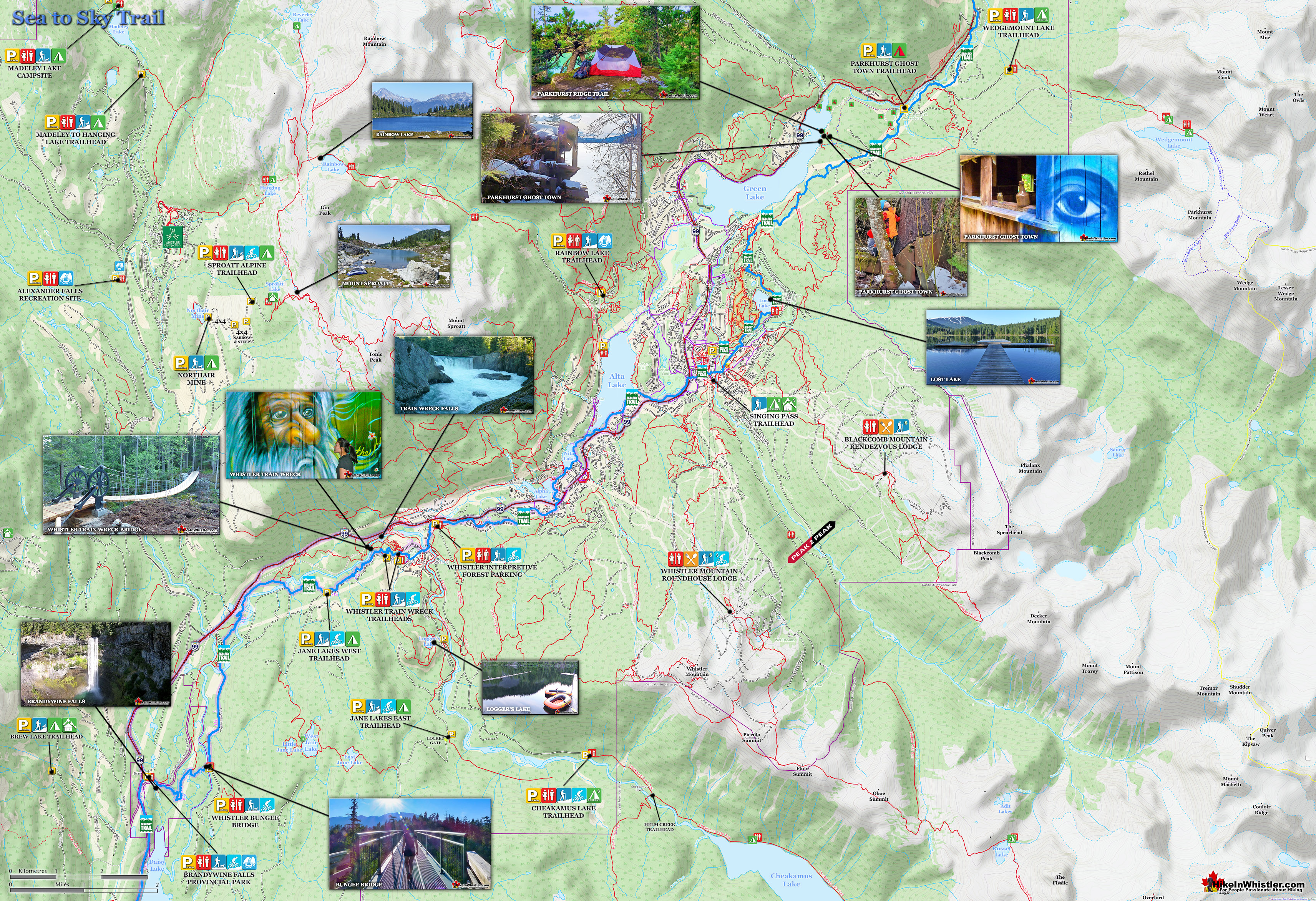
The 33 kilometre Whistler section of the Sea to Sky Trail is either paved, dirt or crushed rock and often very wide. Much of the trail just north and south of Whistler Village is wide, two lanes and paved with plenty of signs and occasional mapboards. North of Whistler Village the trail can be challenging with several hills as it rises above and beyond Parkhurst Ghost Town. South of Whistler, the paved trail ends at Cheakamus Crossing and becomes a narrow at times dirt trail with some wider sections of crushed rock. This beautiful section follows Cheakamus River making four dramatically beautiful river crossings. The Cal-Cheak area south of Cheakamus Crossing is more challenging and sometimes narrow and hilly, dirt trails. South of Cal-Cheak the forest opens up and the trail widens to the luxurious feeling, wide and hard packed gravel all the way to Brandywine Falls Provincial Park where the trail joins with the Sea to Sky Highway. The Whistler section of the Sea to Sky Trail passes near and through an amazing array of whistler sights. The always impressive Brandywine Falls Provincial Park at the southern end of the 33 kilometre area shown here. Heading north from Brandywine Falls you cross the huge bungee jumping bridge that spans the enormous chasm over the Cheakamus River. Soon after you cross the suspension Bridge at the Cal-Cheak Recreation area.
Guides to the Best of Whistler
 Best Dog Friendly Hiking Trails
Whistler is very dog friendly and the number of wonderful hiking trails that your dog will love is huge. The massively varied hiking trails range from easy, short, close to Whistler Village to challenging, long and deep in the endless wilderness around Whistler. You can find dog friendly trails in and around Whistler Village that take you through deep, dark and magical forests. Or you can drive beyond Whistler Village and take your dog to spectacular alpine lakes. Some requiring little or no hiking, while others are found after hiking challenging and long trails. Many of these places are comparatively quiet and often you and your dog will have the the wilderness to yourselves. In and around Whistler Village you have Lost Lake with its spider web of trails... Continued here.
 Best Free Whistler Camping
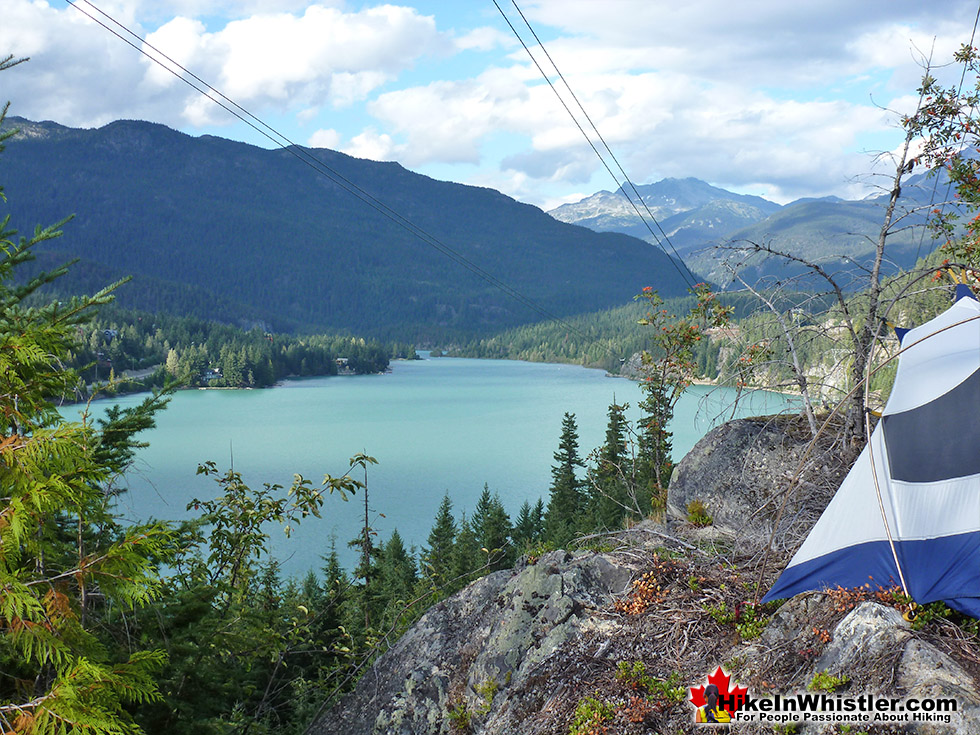
Whistler is surrounded by an immense wilderness dotted with spectacular, hidden lakes and amazing places to set up a tent. Decades of logging activity has left a network of forest service roads that has opened easy access to these places. Some of these you can drive to and some you may need a 4x4 to comfortably get to. Some places to camp for free you can drive to, some require a short hike and others are fairly long hikes to reach. Beautiful Callaghan Valley is home to several incredible and free places to camp. Callaghan Lake has a great free drive-to campsite just steps from this spectacular alpine lake. If you have a canoe, you can paddle to the end of Callaghan Lake and hike the short, but steep trail up to Cirque Lake. This gorgeous lake is deep in the alpine wilderness... Continued here.
 No Car? No Problem! Whistler Trails
Whistler as a resort has a wonderful car-free core. The Village Stroll runs through the heart of Whistler Village and is entirely car free. If you are visiting Whistler or living here and you don't have a car, it's no problem. On foot or on a bike you can travel the extensive network of non-motorized trails. The Valley Trail snakes through Whistler Village and extends in several directions, all of which lead to beautiful parts of Whistler. The Sea to Sky Trail and the Lost Lake trails continue this massive, car-free network of trails running almost everywhere in Whistler. When it comes to many of the best hiking trails, getting to the trailheads on foot, by bike or public transit can be tricky at best or complicated and impractical at worst. Many trailheads are far from Whistler Village and... Continued here.
 Kid Friendly Whistler Hiking Trails
There are plenty of excellent, kid and family friendly hiking trails and destinations in and around Whistler. Kid and family friendly generally means an easy and somewhat short trail that a toddler can happily manage. Some of these trails are flat enough to be stroller friendly, such as Brandywine Falls, Whistler Mountain and Blackcomb Mountain. Others such as Logger’s Lake, Cheakamus River and Madeley Lake have short enough trails to reach them that you can manage with little kids that don't want to hike too far. Some of these hikes and walks are popular and close to Whistler Village, like Whistler Mountain, Blackcomb Mountain, Lost Lake Park, Rainbow Park and Meadow Park. Others are a beautiful, but far drive into the mountains and tricky to find... Continued here.
At Cheakamus Crossing there are some scenic viewpoints of Cheakamus River and a short detour takes you to the extraordinary Whistler Train Wreck. Back on the Sea to Sky Trail heading towards Whistler Village you pass by three of Whistler's beautiful Lakes each with nice parks. Alpha Lake Park, Nita Lake Park and then along Alta Lake you pass Wayside Park and Lakeside Park. The trail then runs through Whistler Village and enters the wonderfully sprawling Lost Lake Park network of trails. As you pass by Lost Lake, the Lost Lake Trail leads you to the Sea to Sky Trail. This section of the Sea to Sky Trail quickly ascends up to the ridge along Green Lake and takes you north to WedgeWood Estates at the northern end of this marvellous 33 kilometres, Whistler stretch of the Sea to Sky Trail.

The Sea to Sky Trail Brandywine Falls to Cheakamus
![]() This is an incredible section of the Sea to Sky Trail. The trail is filled with amazing highlights and viewpoints. There are three convenient places to begin this section of the trail, Brandywine Falls, Calcheak or at Cheakamus Crossing. All have free parking just metres from the trail and all are close to some amazing sights. This description will describe the route south to north as if starting from Brandywine Falls Provincial Park. From the parking lot you will see the large Sea to Sky Trail sign and mapboard indicating where to go. You cross the covered bridge and the first fork in the trail with the Sea to Sky Trail sign pointing right takes you to the Brandywine Falls lookout in 300 metres. Just before the falls lookout there is another sign for the Sea to Sky Trail branching to the left for the Calcheak Suspension Bridge 4 kilometres and Whistler Bungee Bridge 2.6 kilometres.
This is an incredible section of the Sea to Sky Trail. The trail is filled with amazing highlights and viewpoints. There are three convenient places to begin this section of the trail, Brandywine Falls, Calcheak or at Cheakamus Crossing. All have free parking just metres from the trail and all are close to some amazing sights. This description will describe the route south to north as if starting from Brandywine Falls Provincial Park. From the parking lot you will see the large Sea to Sky Trail sign and mapboard indicating where to go. You cross the covered bridge and the first fork in the trail with the Sea to Sky Trail sign pointing right takes you to the Brandywine Falls lookout in 300 metres. Just before the falls lookout there is another sign for the Sea to Sky Trail branching to the left for the Calcheak Suspension Bridge 4 kilometres and Whistler Bungee Bridge 2.6 kilometres.
Brandywine Falls Along the Sea to Sky Trail

Sea to Sky Trail Whistler Bungee Bridge

Whistler Bungee Bridge Aerial View

The Cal-Cheak Suspension Bridge

The Sea to Sky Trail Cheakamus Crossing to Whistler Village
![]() Cheakamus Crossing is surrounded by some amazing sights in Whistler. The Sea to Sky Trail runs along the huge and crashing Cheakamus River. Across the river is the sight of Whistler's most unique and extraordinary places, the Whistler Train Wreck. This wonderful area of train wrecks has morphed into an amazing work of art and an amazing detour just off the Sea to Sky Trail. A new bridge along the Sea to Sky Trail now links "Trash Trail" to Whistler Train Wreck. Built in 2016, there is parking fairly close in Cheakamus Crossing.
Cheakamus Crossing is surrounded by some amazing sights in Whistler. The Sea to Sky Trail runs along the huge and crashing Cheakamus River. Across the river is the sight of Whistler's most unique and extraordinary places, the Whistler Train Wreck. This wonderful area of train wrecks has morphed into an amazing work of art and an amazing detour just off the Sea to Sky Trail. A new bridge along the Sea to Sky Trail now links "Trash Trail" to Whistler Train Wreck. Built in 2016, there is parking fairly close in Cheakamus Crossing.

Cheakamus River
The Sea to Sky Trail crosses Cheakamus River as you leave Cheakamus Crossing and veer toward the Sea to Sky Highway. Just before reaching the highway, the Sea to Sky Trail bends right and ascends up parallel to the highway towards Whistler Village. Back on the Sea to Sky Trail where you came from in Cheakamus Crossing, Whistler Creekside(Whistler Creek) is 3.5 kilometres of constant hills. The trail runs through the neighbourhood of Spring Creek before descending back down to cross the Sea to Sky Highway at the lights at Bayshore Drive. Astonishingly, this is the only significant, traffic related stop along the entire 33 kilometres route (the next Sea to Sky Highway crossing is via a Sea to Sky/Valley Trail underpass that connects the trail, uninterrupted to Whistler Village). After crossing the Sea to Sky Highway the Sea to Sky/Valley Trail takes you past Alpha Lake and the beautiful Alpha Lake Park. Then the trail winds its way past the Whistler Train Station in Creekside and along Nita Lake through Nita Lake Park and Lakeside Park on the popular, scenic and historical Alta Lake. After Lakeside Park the trail veers off through the neighbourhood of Alta Vista, leading to the Whistler Golf Course which then leads to the underpass to Whistler Village.


Parks Along the Sea to Sky Trail
Just before you reach Whistler Village on the Sea to Sky Trail, you will pass another beautiful Whistler park worth visiting. Blueberry Park is a very scenic park on Alta Lake that most Whistler locals don't even know about. If you have been to Rainbow Park you would have noticed three piers across Alta Lake surrounded by forest. These public piers sit at the edge of Blueberry Park, with the Blueberry Trail running from one side of the forest to the other. The park covers most of the hill beyond these piers and stretches between and connects the neighbourhoods of Whistler Cay and Alta Vista.

The Sea to Sky Trail Lost Lake to Green River
![]() Once the Sea to Sky Trail reaches Whistler Village the route to follow becomes a little confused. You have to pass through the heart of Whistler's wonderful Village. If you are on your bike you have to walk it as it is pedestrian only. If you don't want to walk you can easily plot a bike friendly route through the edge of the Village. If you would rather walk through all the action of the Village the most direct route takes you through Village Square and the heart of the Village. The Sea to Sky Trail continues out the far side of the Village, first past Lost Lake, via Lost Lake Park. Lost Lake is a tranquil and secluded lake that hides in the forest extending from Whistler Village. Just a 20 minute, leisurely walk or 5 minute bike ride along the well signed Valley Trail will lead you to this beautiful little lake. The wide and paved Valley Trail turns into a wide and gravel trail as you enter Lost Lake Park. The main trail around the lake is a popular running route from Whistler Village as roundtrip from the Village, around Lost Lake and back to the Village is just 6 kilometres. There are plenty of nice viewpoints along the main trail as well as quite a few short trails that lead to several access points to the lake, some with great places to sit and relax in the sun and take in the view.
Once the Sea to Sky Trail reaches Whistler Village the route to follow becomes a little confused. You have to pass through the heart of Whistler's wonderful Village. If you are on your bike you have to walk it as it is pedestrian only. If you don't want to walk you can easily plot a bike friendly route through the edge of the Village. If you would rather walk through all the action of the Village the most direct route takes you through Village Square and the heart of the Village. The Sea to Sky Trail continues out the far side of the Village, first past Lost Lake, via Lost Lake Park. Lost Lake is a tranquil and secluded lake that hides in the forest extending from Whistler Village. Just a 20 minute, leisurely walk or 5 minute bike ride along the well signed Valley Trail will lead you to this beautiful little lake. The wide and paved Valley Trail turns into a wide and gravel trail as you enter Lost Lake Park. The main trail around the lake is a popular running route from Whistler Village as roundtrip from the Village, around Lost Lake and back to the Village is just 6 kilometres. There are plenty of nice viewpoints along the main trail as well as quite a few short trails that lead to several access points to the lake, some with great places to sit and relax in the sun and take in the view.

Lost Lake
Lost Lake has a very popular beach at one end and in the height of summer can get busy as it is the most convenient beach from Whistler Village. There are several swimming platforms out in the lake as well as a wonderful and huge pier along the right hand side of the lake. An amazing place to catch the sunsets over Whistler Mountain. In the winter months when there is snow in Whistler, Lost Lake becomes a cross country and snowshoeing area and there is a charge to access the main trails around the lake. Usually from mid December to early April. As you continue past Lost Lake you will see a small Sea to Sky Trail sign pointing to the right and directing you up into the beautiful trail above Green Lake that leads you up past Green Lake and comes out near the turnoff to Wedgemount Lake. This section of the Sea to Sky Trail above Green Lake is wide, gravel and somewhat steep. Lots of steep switchbacks get you ascending quickly above Green Lake. This section of the trail is remarkably windy which makes it quite fun as your view constantly changes.


Sea to Sky Trail to Parkhurst Ghost Town
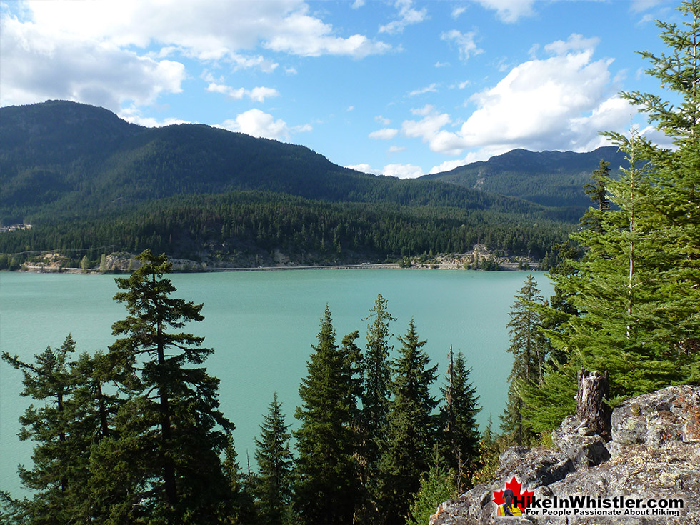
This highlight of this stretch of the trail, apart from the beautiful views of Green Lake, is Parkhurst Ghost Town. Shortly after you begin your steep descent on the far side of Green Lake you will see an unmarked trail on your left. This leads you to this amazing relic of pre-Whistler history. Parkhurst was a small logging town from 1926 to 1956 that was abandoned. Despite the harsh winters with crushing snow, two resilient houses still stand. One has been adorned with an amazing and haunting mural of a blue face in 2011 by local muralist Kris Kupskay. Elsewhere in the area you find strange artifacts, several old vehicles, logging equipment and dozens of flattened houses. Down on the shore of Green Lake you find an extraordinary and enormous Caterpillar tractor from 1939 is perched on the shore as if waiting for the next batch of logs to move!


Back on the Sea to Sky Trail a few more descending switchbacks lead you to a logging road which leads you down to the Green River crossing to the Sea to Sky Highway. This is where you often have to park in the winter to access the Sea to Sky Trail and Parkhurst as this logging road is buried in snow. The Sea to Sky Trail is still under sporadic construction in this area. You may spot a sign here that shows the trail continuing to the new Whistler neighbourhood of WedgeWood Estates.

This short(.8k) section can be found by just going up the gravel road towards the final Wedgemount Lake turnoff. Turn left before this turnoff and follow the gravel road through the construction zone that is WedgeWood Estates. This just leads to the Sea to Sky Highway and at the moment is not really worth doing. This is the end of the (almost) entirely uninterrupted Whistler section of the Sea to Sky Trail. With the exception of a few very short road sections, this 33 kilometre trail was on a beautiful, paved, sometimes dirt, but usually wide, crushed rock trail.
Whistler's Best Hiking Trails!
Whistler & Garibaldi Park Best Hiking by Month!


Explore BC Hiking Destinations!

Whistler Hiking Trails

Squamish Hiking Trails

Vancouver Hiking Trails

Clayoquot Hiking Trails
Victoria Hiking Trails

