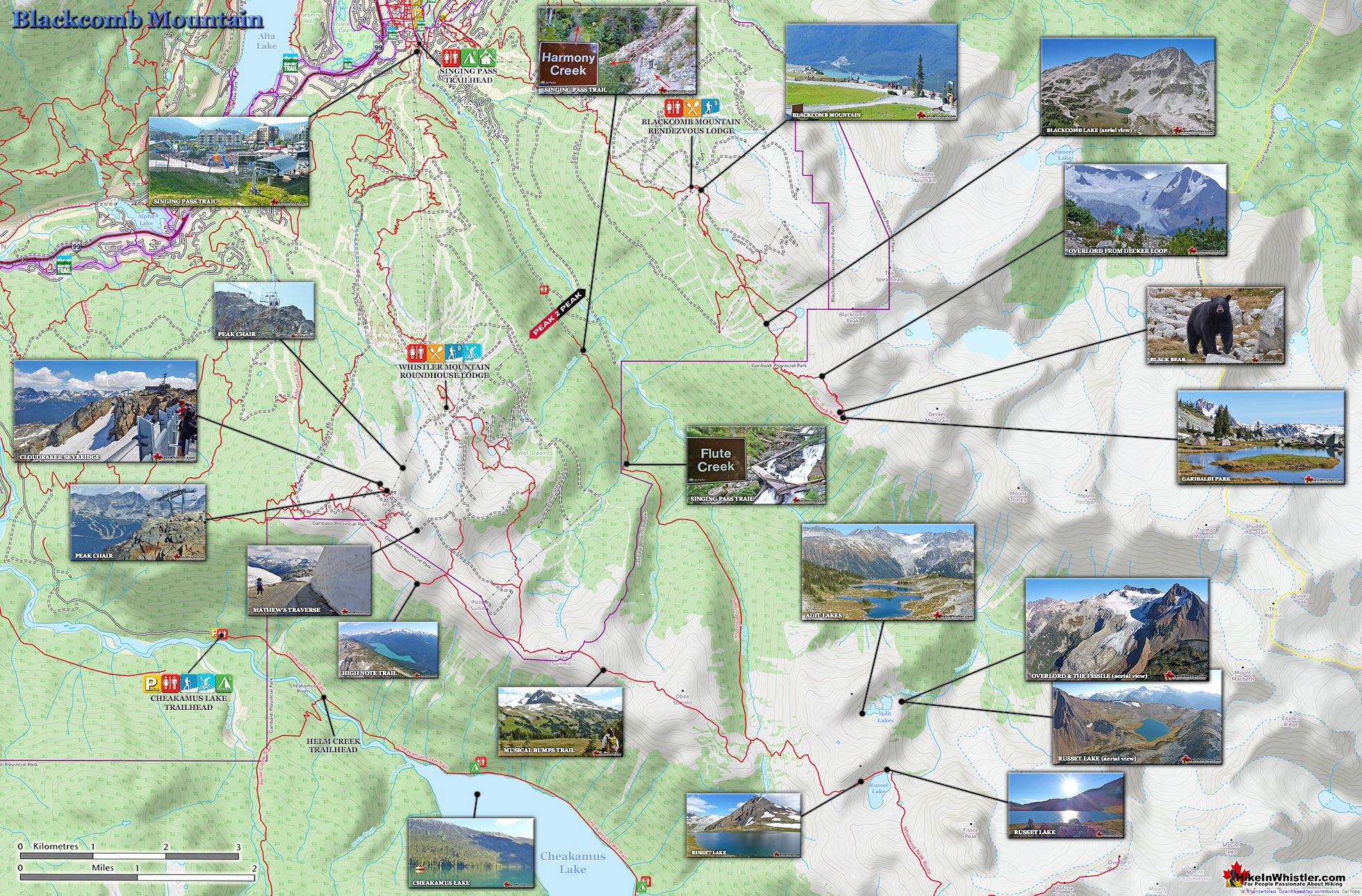
![]() Blackcomb Mountain holds an impressive and ever growing array of hiking trails. From the moment you arrive at the Rendezvous Lodge, you see hiking trails ascend into the distance. The Rendezvous Lodge is home to a cafeteria style restaurant, a fine dining restaurant, gift shops, washrooms, and quite a lot else. The Rendezvous Lodge is centre of activity on Blackcomb Mountain and the Roundhouse Lodge is the same on Whistler Mountain.
Blackcomb Mountain holds an impressive and ever growing array of hiking trails. From the moment you arrive at the Rendezvous Lodge, you see hiking trails ascend into the distance. The Rendezvous Lodge is home to a cafeteria style restaurant, a fine dining restaurant, gift shops, washrooms, and quite a lot else. The Rendezvous Lodge is centre of activity on Blackcomb Mountain and the Roundhouse Lodge is the same on Whistler Mountain.
 Little effort, amazing alpine scenery
- Easily escape the crowds by hiking longer trails
- Rendezvous Lodge is great for dining & drinking
- Accessing alpine terrain beyond trails is easy
- Unmarked route continues to Russet Lake
- Bivouacking beyond marked trails is amazing
- Extraordinary views of Whistler Mountain & more
- Distant Overlord Glacier is stunning
- Very organized trails & route markers/maps
 Access is restricted by snow to early June
Whether you are doing a long hike or just one of the short ones, stopping here before and after for a meal and/or a beer is almost essential. Blackcomb Mountain has come alive with beautiful hiking trails in recent years. With the 2008 addition of the Peak2Peak Gondola which connects Blackcomb Mountain to Whistler Mountain, the demand for mountain trails is higher than ever. A dozen years ago, you would just have had some rough hiking trails to follow, and not many hikers to follow them. Now you have mapboards, trail signs, viewpoint seating areas and six popular, named trails to hike. The majority of the Blackcomb Mountain trails are easy and relaxing, however the Decker Loop trail at the far end of Blackcomb Mountain is very challenging and spectacularly scenic. For the most part, you will find yourself winding through a nice alpine forest scattered with enormous fields of erratics leading to one great viewpoint after another.
 No Car? No Problem! Whistler Trails
Whistler as a resort has a wonderful car-free core. The Village Stroll runs through the heart of Whistler Village and is entirely car free. If you are visiting Whistler or living here and you don't have a car, it's no problem. On foot or on a bike you can travel the extensive network of non-motorized trails. The Valley Trail snakes through Whistler Village and extends in several directions, all of which lead to beautiful parts of Whistler. The Sea to Sky Trail and the Lost Lake trails continue this massive, car-free network of trails running almost everywhere in Whistler. When it comes to many of the best hiking trails, getting to the trailheads on foot, by bike or public transit can be tricky at best or complicated and impractical at worst. Many trailheads are far from Whistler Village and... Continued here.
 Best Dog Friendly Hiking Trails
Whistler is very dog friendly and the number of wonderful hiking trails that your dog will love is huge. The massively varied hiking trails range from easy, short, close to Whistler Village to challenging, long and deep in the endless wilderness around Whistler. You can find dog friendly trails in and around Whistler Village that take you through deep, dark and magical forests. Or you can drive beyond Whistler Village and take your dog to spectacular alpine lakes. Some requiring little or no hiking, while others are found after hiking challenging and long trails. Many of these places are comparatively quiet and often you and your dog will have the the wilderness to yourselves. In and around Whistler Village you have Lost Lake with its spider web of trails... Continued here.
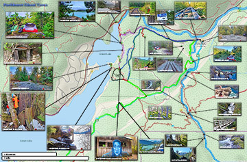
Whistler and Blackcomb Mountain Map
Blackcomb and Whistler mountains have a staggering number of sights to see in the summertime. The hiking trails on Blackcomb start from Rendezvous Lodge, high up on Blackcomb. To get there you can take the Blackcomb Gondola from the Upper Village or the Peak 2 Peak Gondola from Whistler Mountain.

Blackcomb View of Green Lake
This beautiful viewpoint overlooking Green Lake is found next to Rendezvous Lodge. Both the Blackcomb Gondola and the Peak 2 Peak Gondola are also just steps away.


More Hiking Info for Blackcomb Mountain...
 Best Free Whistler Camping
Whistler is surrounded by an immense wilderness dotted with spectacular, hidden lakes and amazing places to set up a tent. Decades of logging activity has left a network of forest service roads that has opened easy access to these places. Some of these you can drive to and some you may need a 4x4 to comfortably get to. Some places to camp for free you can drive to, some require a short hike and others are fairly long hikes to reach. Beautiful Callaghan Valley is home to several incredible and free places to camp. Callaghan Lake has a great free drive-to campsite just steps from this spectacular alpine lake. If you have a canoe, you can paddle to the end of Callaghan Lake and hike the short, but steep trail up to Cirque Lake. This gorgeous lake is deep in the alpine wilderness... Continued here.
 Kid Friendly Whistler Hiking Trails
There are plenty of excellent, kid and family friendly hiking trails and destinations in and around Whistler. Kid and family friendly generally means an easy and somewhat short trail that a toddler can happily manage. Some of these trails are flat enough to be stroller friendly, such as Brandywine Falls, Whistler Mountain and Blackcomb Mountain. Others such as Logger’s Lake, Cheakamus River and Madeley Lake have short enough trails to reach them that you can manage with little kids that don't want to hike too far. Some of these hikes and walks are popular and close to Whistler Village, like Whistler Mountain, Blackcomb Mountain, Lost Lake Park, Rainbow Park and Meadow Park. Others are a beautiful, but far drive into the mountains and tricky to find... Continued here.
 Best Sights Sea to Sky 99
The Sea to Sky Highway links Vancouver to Whistler and has several stops along the way that are often overlooked. Porteau Cove, for example, is surprisingly unknown even to locals that have driven past hundreds of times. Just off the highway the parking area is just steps from the huge pier stretching way out over the ocean. This gigantic pier is actually a rarely used emergency dock for BC Ferries, though more often used by visitors for its stunning views of Howe Sound. Porteau Cove is an excellent pit stop on the way to Whistler, not only for the spectacular views of Howe Sound, but one of the nicest picnic spots and most convenient restrooms! Other attractions along the Sea to Sky Highway are more obvious, such as Shannon Falls, the Sea to Sky Gondola... Continued here.
 Best Whistler Waterfalls
There are lots of beautiful waterfalls in and around Whistler. From the towering drop of Brandywine Falls to the awesome, up close and breathtaking view of Keyhole Falls. Some are absurdly convenient and easy to see and others require some tough hiking, or tricky driving to get to. All of them, however, are well worth a visit. Brandywine Falls is the most well known, impressive and easy to find along the Sea to Sky Highway. The viewing platform positioned across from the falls gives you a direct view of its 66 metre(216 feet) plunge into the chasm below. Located 17.1 kilometres(10.6 miles) from Whistler Village. The short, 1 kilometre long, dog friendly trail to the viewpoint is wide and smooth gravel. Alexander Falls, located up... Continued here.
 Whistler Train Wreck Murals
The colourful graffiti and murals that make Whistler Train Wreck the magical place it is today began appearing in 2011, when this hidden place was known by just a few Whistler locals. In the summer of 2011 several Whistler artists came here for "The Train Wreck Paint Jam" and transformed the mangled wreckage into a surreal art exhibit. The artists ranged from aspiring graffiti artists to professional artists like Kups. Remnants of one of his murals from 2011 is found inside the first boxcar you come to after crossing the bridge into Whistler Train Wreck. Several of the original murals were gorgeous. Brilliantly coloured and surreal in such an unusual, tranquil and hidden forest with seven mangled train boxcars scattered. Like some sort of haunting art gallery... Continued here.
More Whistler & Garibaldi Park Hiking Maps!
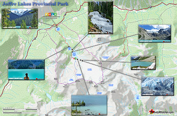
Joffre Lakes Maps
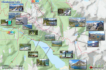
Cheakamus Lake Maps
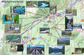
Train Wreck Maps
Parkhurst Ghost Town Maps

Whistler & Garibaldi Park Glossary A to Z

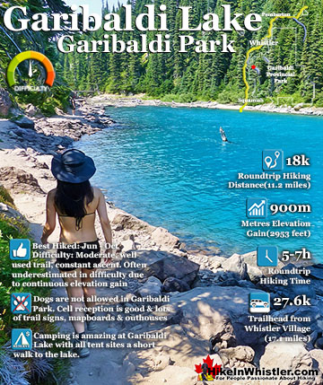
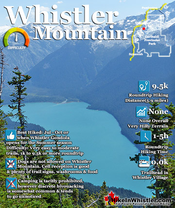
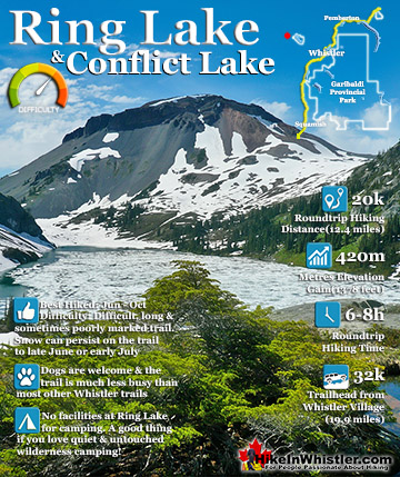
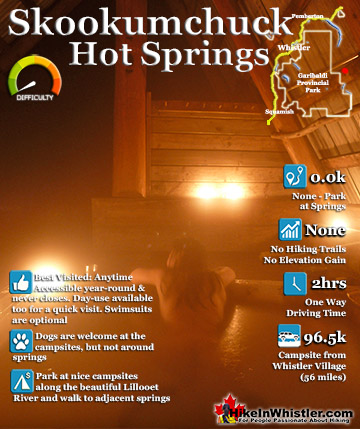
The Best Whistler & Garibaldi Park Hiking Trails!