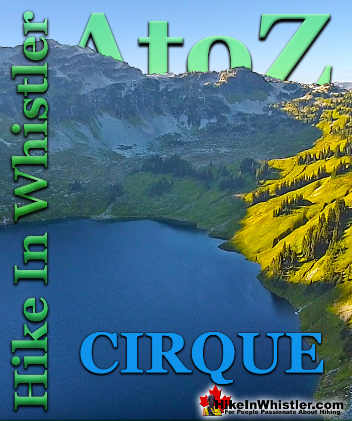
![]() Cirque: a glacier-carved bowl or amphitheater in the mountains. To form, the glacier must be a combination of size, a certain slope and more unexpectedly, a certain angle away from the sun. In the northern hemisphere, this means the glacier must be on the northeast slope of the mountain, away from the suns rays and the prevailing winds. Thick snow, protected in this way, grows thicker into glacial ice, then a process of freeze-thaw called nivation, chews at the lower rocks, hollowing out a deep basin.
Cirque: a glacier-carved bowl or amphitheater in the mountains. To form, the glacier must be a combination of size, a certain slope and more unexpectedly, a certain angle away from the sun. In the northern hemisphere, this means the glacier must be on the northeast slope of the mountain, away from the suns rays and the prevailing winds. Thick snow, protected in this way, grows thicker into glacial ice, then a process of freeze-thaw called nivation, chews at the lower rocks, hollowing out a deep basin.
Whistler & Garibaldi Hiking
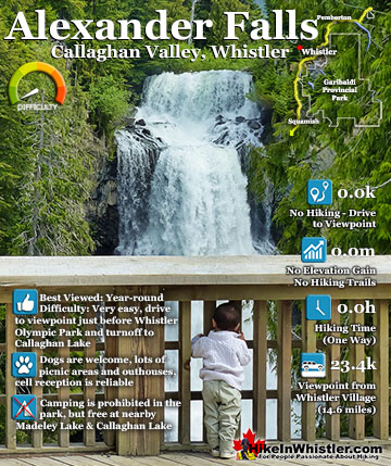
![]() Alexander Falls
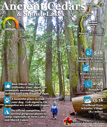
Alexander Falls ![]() Ancient Cedars
Ancient Cedars ![]() Black Tusk
Black Tusk ![]() Blackcomb Mountain
Blackcomb Mountain ![]() Brandywine Falls
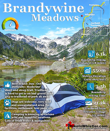
Brandywine Falls ![]() Brandywine Meadows
Brandywine Meadows ![]() Brew Lake
Brew Lake ![]() Callaghan Lake
Callaghan Lake ![]() Cheakamus Lake
Cheakamus Lake ![]() Cheakamus River
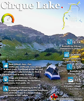
Cheakamus River ![]() Cirque Lake
Cirque Lake ![]() Flank Trail
Flank Trail ![]() Garibaldi Lake
Garibaldi Lake ![]() Garibaldi Park
Garibaldi Park ![]() Helm Creek
Helm Creek ![]() Jane Lakes
Jane Lakes ![]() Joffre Lakes
Joffre Lakes ![]() Keyhole Hot Springs
Keyhole Hot Springs ![]() Logger’s Lake
Logger’s Lake ![]() Madeley Lake
Madeley Lake ![]() Meager Hot Springs
Meager Hot Springs ![]() Nairn Falls
Nairn Falls ![]() Newt Lake
Newt Lake ![]() Panorama Ridge
Panorama Ridge ![]() Parkhurst Ghost Town
Parkhurst Ghost Town ![]() Rainbow Falls
Rainbow Falls ![]() Rainbow Lake
Rainbow Lake ![]() Ring Lake
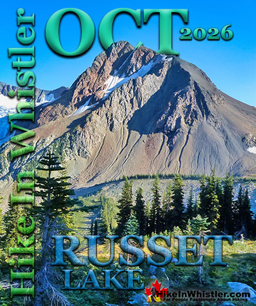
Ring Lake ![]() Russet Lake
Russet Lake ![]() Sea to Sky Trail
Sea to Sky Trail ![]() Skookumchuck Hot Springs
Skookumchuck Hot Springs ![]() Sloquet Hot Springs
Sloquet Hot Springs ![]() Sproatt East
Sproatt East ![]() Sproatt West
Sproatt West ![]() Taylor Meadows
Taylor Meadows ![]() Train Wreck
Train Wreck ![]() Wedgemount Lake
Wedgemount Lake ![]() Whistler Mountain
Whistler Mountain
![]() January
January ![]() February
February ![]() March
March ![]() April
April ![]() May
May ![]() June
June ![]() July
July ![]() August
August ![]() September
September ![]() October
October ![]() November
November ![]() December
December
Eventually a magnificently circular lake is formed with steep sloping sides all around. Cirque Lake just south of Whistler in the Callaghan Valley is a wonderful example of one of these beautiful geological formations. Cirque Lake in Whistler is accessible by a short canoe route across Callaghan Lake, then a very steep and challenging two kilometre hike. The trailhead to Cirque Lake is found at the far end of Callaghan Lake. The Callaghan Lake turnoff is 20km south of Whistler Village. From Whistler drive 20km towards Vancouver, then turn right at the sign for Whistler Olympic Park. Drive up the beautiful, winding road for about 8 minutes. The sign for Callaghan Lake will be just before Whistler Olympic Park, you will turn left, cross a bridge and drive a bumpy logging road for 8km. Cirque Lake is one of the most beautiful lakes to visit in the Whistler area. The wild and hostile environment contained in a cirque valley create a staggeringly enchanting world high above Callaghan Lake. It is very remote feeling despite the short 2 kilometre hike to reach it. Getting to the trailhead requires paddling the length of Callaghan Lake to find the hardly visible beginning of the trail. To reach the very hidden trailhead to Cirque Lake, paddle your canoe towards the waterfall far off in the distance. Not until you are only 50 metres from the shore, nearest the sound of the now hidden waterfall, you will see a small clearing jutting out from the shore, this is the trailhead, despite it not looking like one. Pull your canoe up here and drag into the bushes. Only a few metres into shore you will notice an obvious trail. Callaghan Lake is a destination on its own. A beautiful alpine lake, well above the busy world around Whistler Village. Bring a canoe and paddle across the lake to find amazing rock cliffs and cute little islands.


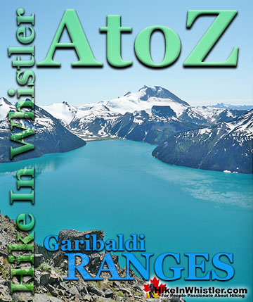
The image above is an aerial view of Cirque Lake from the top of the valley near Sky Lakes. Sky Lakes is a beautiful, unmarked route that takes you along the edge of Cirque Lake, then veers to the right and up the green meadow higher into the alpine. After you reach the top of the valley, you will see a series of lakes called Sky Lakes. Their name comes from the mirror-like reflection of the sky you see when you first catch sight of them from the ridge above. The above image shows the glacier carved shape of Cirque Lake and Mount Callaghan above. The image below shows the steep, boulder section of the Cirque Lake hiking trail and Callaghan Lake in the background. Further in the far distance you can spot Black Tusk and Mount Garibaldi quite easily.

Plenty of great views of Callaghan Lake from the Cirque Lake trail. The image below is shorty after climbing the big boulder section of the trail. There is a nice, huge flat area and this cliff overlooking the lake. From here, Cirque Lake is just a 4 minute, leisurely hike away.

Finding an area flat enough to put up a tent is tough at Cirque Lake. The terrain around the lake is rocky and mostly sloping. There is this nice area overlooking the lake that you come to immediately when you arrive at the end of the Cirque Lake trail. The shore of the lake is just a 1 minute walk down the rocky scree slope on the right. The route to Sky Lakes is off to the right, following the scree slope as it ascends into the green meadow where the sun is shining.

Cirque Lake is beautifully carved by glaciers into this round shape. The lake is very deep and the crystal clear water is emerald green coloured and brutally cold, even on a hot August day. Swimming in the lake is actually a bit spooky as you can see for several metres into the water below you until it becomes black with the depth.


More Great Hiking Around Callaghan Lake
![]() The Callaghan Valley lays quietly across from Whistler despite being home to some incredible hikes. Ring & Conflict Lake and Cirque Lake are two phenomenal hiking destinations in the valley that few people have even heard of. Cirque Lake resides high above Callaghan Lake at the end of a very steep, though very short hike that runs startlingly close to the almost vertical falls that empty Cirque Lake. Ring & Conflict Lake sit high up in the mountains 10 kilometres west of Callaghan Lake. You will never, or at least comparatively rarely see anyone on the trails to Cirque Lake, Ring & Conflict Lake for several reasons. First is location. Despite the Callaghan Valley being tremendously beautiful geographically. The distant mountains are snow covered, even in September. The lakes are emerald coloured and crystal clear. The forests are an untouched blanket of beautiful green. The creeks, rivers and waterfalls are everywhere in your view or if not in view, heard as distant sounds of running water. Despite this beauty, it seems that the biggest reason for the Callaghan Valley's lack of use as a hiking destination is its location next to Garibaldi Park. The beautiful and well known park focuses all the throngs of hikers in the justifiably popular areas of Garibaldi Lake, Black Tusk, Taylor Meadows, Wedgemount Lake and Elfin Lakes. Laying outside this monstrously famous Provincial Park exists the relatively untouched and unknown Callaghan Valley. The second big reason of course is that the hikes in the Callaghan Valley are unmaintained or at least rarely maintained. The campsite at Callaghan Lake is maintained to a very high standard, however the trail to Cirque Lake evidently doesn't fall into any park jurisdiction and finding the unmarked trailhead is a challenge. There are flagging tapes along the trail after the trailhead. The third reason, at least for Cirque Lake, for being hardly hiked is the fact that the unmarked trailhead starts at the far end of Callaghan Lake. So you need to canoe or otherwise, boat there. This added impediment surely contributes to this wonderful trail, continuing to be infrequently hiked. The fourth, more practical, yet inexplicable reason is that the road to Callaghan Lake Provincial Park is horribly unmaintained. Obviously grading this poor logging road is expensive, however it is beyond neglected. Boulders, waterbars and potholes exist on this road to such a high degree that the neglect seems malicious. In fact, the moment you leave the deluxe road to the Olympic Nordic Centre the monstrous potholes begin, presumably scaring away any 4x4 lacking tourists Callaghan Lake Provincial Park bound. The Callaghan Valley gets a lot of drive in traffic since the recent paving of the road and installation of Whistler Olympic Park for the 2010 Olympics. This road is open year-round and in the summer is frequented by bear watchers. The grass along the road is a favourite for bears and in the summer months consistently ensures at least a couple bears along the route to the Callaghan Valley. Whistler has quite a few beautiful waterfalls to see. From Squamish there is Shannon Falls, then Brandywine Falls closer to Whistler. Rainbow Falls in Whistler and Nairn Falls twenty minutes north. Out of these, Alexander Falls in the Callaghan Valley is both impressively huge and convenient to see. It is located just before the turnoff to Callaghan Lake. You can drive to the viewing platform and actually see the falls without leaving your car.
The Callaghan Valley lays quietly across from Whistler despite being home to some incredible hikes. Ring & Conflict Lake and Cirque Lake are two phenomenal hiking destinations in the valley that few people have even heard of. Cirque Lake resides high above Callaghan Lake at the end of a very steep, though very short hike that runs startlingly close to the almost vertical falls that empty Cirque Lake. Ring & Conflict Lake sit high up in the mountains 10 kilometres west of Callaghan Lake. You will never, or at least comparatively rarely see anyone on the trails to Cirque Lake, Ring & Conflict Lake for several reasons. First is location. Despite the Callaghan Valley being tremendously beautiful geographically. The distant mountains are snow covered, even in September. The lakes are emerald coloured and crystal clear. The forests are an untouched blanket of beautiful green. The creeks, rivers and waterfalls are everywhere in your view or if not in view, heard as distant sounds of running water. Despite this beauty, it seems that the biggest reason for the Callaghan Valley's lack of use as a hiking destination is its location next to Garibaldi Park. The beautiful and well known park focuses all the throngs of hikers in the justifiably popular areas of Garibaldi Lake, Black Tusk, Taylor Meadows, Wedgemount Lake and Elfin Lakes. Laying outside this monstrously famous Provincial Park exists the relatively untouched and unknown Callaghan Valley. The second big reason of course is that the hikes in the Callaghan Valley are unmaintained or at least rarely maintained. The campsite at Callaghan Lake is maintained to a very high standard, however the trail to Cirque Lake evidently doesn't fall into any park jurisdiction and finding the unmarked trailhead is a challenge. There are flagging tapes along the trail after the trailhead. The third reason, at least for Cirque Lake, for being hardly hiked is the fact that the unmarked trailhead starts at the far end of Callaghan Lake. So you need to canoe or otherwise, boat there. This added impediment surely contributes to this wonderful trail, continuing to be infrequently hiked. The fourth, more practical, yet inexplicable reason is that the road to Callaghan Lake Provincial Park is horribly unmaintained. Obviously grading this poor logging road is expensive, however it is beyond neglected. Boulders, waterbars and potholes exist on this road to such a high degree that the neglect seems malicious. In fact, the moment you leave the deluxe road to the Olympic Nordic Centre the monstrous potholes begin, presumably scaring away any 4x4 lacking tourists Callaghan Lake Provincial Park bound. The Callaghan Valley gets a lot of drive in traffic since the recent paving of the road and installation of Whistler Olympic Park for the 2010 Olympics. This road is open year-round and in the summer is frequented by bear watchers. The grass along the road is a favourite for bears and in the summer months consistently ensures at least a couple bears along the route to the Callaghan Valley. Whistler has quite a few beautiful waterfalls to see. From Squamish there is Shannon Falls, then Brandywine Falls closer to Whistler. Rainbow Falls in Whistler and Nairn Falls twenty minutes north. Out of these, Alexander Falls in the Callaghan Valley is both impressively huge and convenient to see. It is located just before the turnoff to Callaghan Lake. You can drive to the viewing platform and actually see the falls without leaving your car.


More Whistler & Garibaldi Park Hiking A to Z!


The Best Whistler & Garibaldi Park Hiking Trails!
Whistler & Garibaldi Park Best Hiking by Month!


Explore BC Hiking Destinations!

Whistler Hiking Trails

Squamish Hiking Trails

Vancouver Hiking Trails

Clayoquot Hiking Trails
Victoria Hiking Trails

