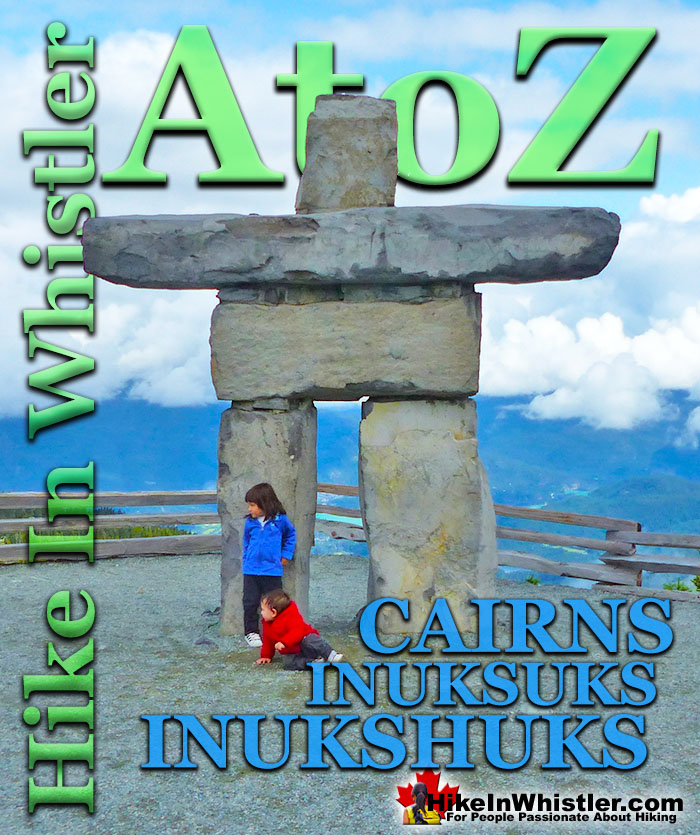
Cairns, inukshuks or inuksuks are a pile or arrangement of rocks used to indicate a route, landmark or a summit. The word cairn originates from the Scottish Gaelic word carn. A cairn or inukshuk can be either large and elaborate or as simple as a small pile of rocks. To be effective a cairn marking a trail has to just be noticeable and obviously man-made. In the alpine areas around Whistler, above the treeline, cairns are the main method of marking a route.
In the spring and fall when snow covers alpine trails, cairns mark many routes. An inukshuk(also spelled inuksuk) is the name for a cairn used by peoples of the Arctic region of North America. Both spelling versions are pronounced nearly as they are spelled. So inukshuk is pronounced inook-shuk, and inuksuk with inook-suk. Though an inukshuk can take many forms similar to a cairn, it is usually represented by large rocks formed into a human shape. The word inukshuk literally translates from two separate Inuit words, inuk "person" and suk "substitute". The 2010 Winter Olympics in Vancouver and Whistler used the inukshuk for the logo of the games. Today you will find several giant rock inukshuks in Vancouver and Whistler at various places. In Whistler there is an impressive inukshuk, several metres high a the peak of Whistler Mountain. Another huge inukshuk sits overlooking Whistler Valley at the Roundhouse next to the Umbrella Bar. The first inukshuk that most visitors to Whistler see is the huge one on Village Gate Boulevard.
Inukshuk Near the Roundhouse
Whistler Peak Inukshuk
Inukshuk and Distant Black Tusk
Battleship Islands Cairns, Garibaldi Lake
More Whistler & Garibaldi Park Hiking A to Z!
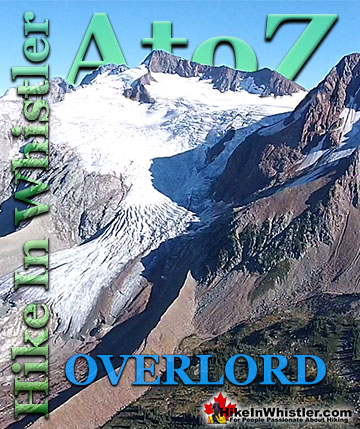
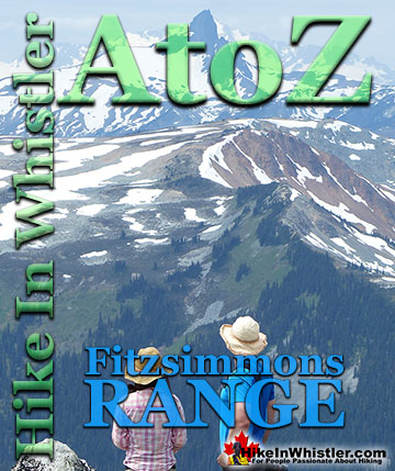
Overlord Mountain is the highest peak in the Fitzsimmons Range. Overlord is surrounded by several mountains that collectively are named the Overlord ...
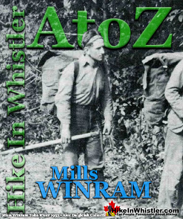
Mills Winram was a very active mountaineer from Vancouver with some very notable ascents in the 1920's and 1930's. He, along with Fred Parkes and Stan ...
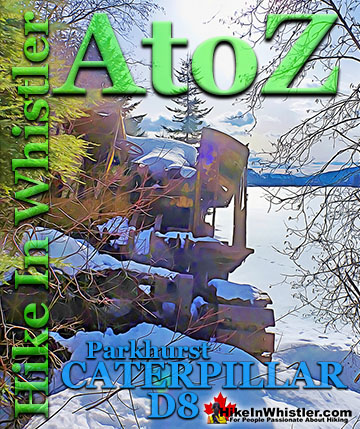
Along the shore of Green Lake, you will find a monstrous old Caterpillar tractor that dates from the 1930’s. Abandoned here in the 1950’s, it looks as if the ...
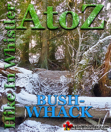
Bushwhack is a term often used in Canada and the United States to refer to hiking off-trail where no trail exists. Literally means 'bush' and 'whack'. To ...
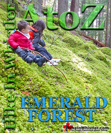
Emerald Forest is a cute little forest that is well hidden between Whistler Cay and Alpine. From Whistler Village, if you go down to the end of Lorimer ...
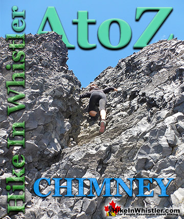
Chimney: a gap between two vertical faces of rock or ice. Often a chimney offers the only viable route to the summit of a mountain. An example of this is Black ...
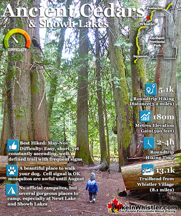
Ancient Cedars is a nice, easy/moderate 2.5 kilometre (1.6 mile) hiking trail on the far side of Cougar Mountain, just 13.1 kilometres north of Whistler Village. A small, untouched grove of huge western ...
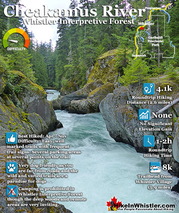
Cheakamus River is a beautiful, crashing, turquoise coloured river that flows from Cheakamus Lake, through Whistler Interpretive Forest, then down past Brandywine Falls to Daisy Lake, then all the way to ...
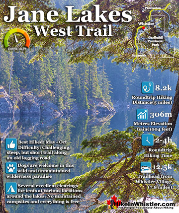
Jane Lakes are a very remote feeling set of lakes in the beautiful wilderness near Cheakamus Crossing. Consisting of three lakes, West Jane Lake, East Jane Lake and Little Jane Lake, they have a great ...
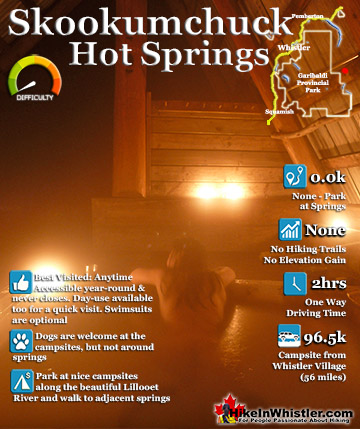
Skookumchuck Hot Springs(aka T'sek Hot Springs and St. Agnes Well), located two hours north of Whistler along the edge of the huge Lillooet River. The name Skookumchuck means "strong water" in the language ...
July is a wonderful time to hike in Whistler and Garibaldi Provincial Park. The weather is beautiful and the snow on high elevation hiking trails is long ...
August hiking in Whistler definitely has the most consistently great, hot weather. You can feel the rare pleasure of walking across a glacier shirtless and ...
September hiking in Whistler is possibly the best month of all. The snow has melted far up to the mountain tops, yet the temperatures are still quite ...
Hiking in Whistler in October is often unexpectedly stunning. The days are much shorter and colder but the mountains are alive with colour from the fall ...
Hiking in Whistler is spectacular and wonderfully varied. Looking at a map of Whistler you see an extraordinary spider web of hiking trails that are unbelievably numerous. Easy trails, moderate trails and challenging hiking trails are all available. Another marvellous ...
Squamish is located in the midst of a staggering array of amazing hiking trails. Garibaldi Provincial Park sprawls alongside Squamish and up and beyond Whistler. Tantalus Provincial Park lays across the valley to the west and the wonderfully remote Callaghan Valley ...
Vancouver is surrounded by seemingly endless hiking trails and mountains to explore. Massive parks line up one after another. Mount Seymour Provincial Park, Lynn Canyon Park, Grouse Mountain, Cypress Park and the enormous Garibaldi Park all contribute to Vancouver ...
Clayoquot Sound has a staggering array of hiking trails within it. Between Tofino and Ucluelet, Pacific Rim Park has several wilderness and beach trails, each one radically different from the last. The islands in the area are often Provincial parks on their own with ...
Victoria has a seemingly endless number of amazing hiking trails. Most take you to wild and beautiful Pacific Ocean views and others take you to tranquil lakes in beautiful BC Coastal Rainforest wilderness. Regional Parks and Provincial Parks are everywhere you turn ...
The West Coast Trail was created after decades of brutal and costly shipwrecks occurred along the West Coast of Vancouver Island. One shipwreck in particular was so horrific, tragic and unbelievable that it forced the creation of a trail along the coast, which ...