HikeInWhistler.com

HikeInWhistler.com

Menu
  • Hike
      • Alexander Falls Provincial Park
      • Ancient Cedars & Showh Lakes
      • Black Tusk in Garibaldi Park
      • Blackcomb Mountain Hiking Trails
      • Brandywine Falls Provincial Park
      • Brandywine Meadows
      • Brew Lake & Mount Brew
      • Callaghan Lake Park
      • Cheakamus Lake in Garibaldi Park
      • Cheakamus River & Interpretive Forest
      • Cirque Lake in Callaghan Valley
      • Flank Trail (Rainbow-Sproatt)
      • Garibaldi Lake in Garibaldi Park
      • Helm Creek in Garibaldi Park
      • Jane Lakes West
      • Joffre Lakes Provincial Park
      • Keyhole Hot Springs
      • Logger's Lake
      • Madeley Lake & Hanging Lake
      • Meager Hot Springs
      • Nairn Falls Provincial Park
      • Newt Lake & Ancient Cedars
      • Panorama Ridge in Garibaldi Park
      • Parkhurst Ghost Town
      • Rainbow Falls
      • Rainbow Lake
      • Ring Lake & Conflict Lake
      • Russet Lake in Garibaldi Park
      • Sea to Sky Trail
      • Skookumchuck Hot Springs
      • Sloquet Hot Springs
      • Sproatt West(Northair) Trail
      • Sproatt East(Stonebridge) Trail
      • Train Wreck & Trash Trail
      • Taylor Meadows in Garibaldi Park
      • Wedgemount Lake in Garibaldi Park
      • Whistler Mountain Hiking Trails
  • Snow
      • Blueberry Trail Snowshoeing
      • Brandywine Falls Snowshoeing
      • Cheakamus River Snowshoeing
      • Elfin Lakes Snowshoeing
      • Flank Trail Snowshoeing
      • Joffre Lakes Snowshoeing
      • Nairn Falls Snowshoeing
      • Parkhurst Ghost Town Snowshoeing
      • Rainbow Falls Snowshoeing
      • Rainbow Lake Snowshoeing
      • Rainbow Park Snowshoeing
      • Sproatt East Snowshoeing
      • Taylor Meadows Snowshoeing
      • Train Wreck Snowshoeing
      • Wedgemount Lake Snowshoeing
  • Run
      • Whistler Golf Course 5k(3.1 Mile)
      • Blueberry Hill 6k(3.7 Mile)
      • Lost Lake 6k(3.7 Mile)
      • Alta Lake 8k(5 Mile)
      • Fitzsimmons Creek 9k(5.6 Mile)
      • Alta Green Lost 15k(9.3 Mile)
  • Best
      • Best Whistler Hiking by Month
          • Best by Month
      • Best Walk, Bike or Bus To Trails
      • Best Whistler Kid Friendly Trails
      • Best Whistler Dog Friendly Trails
      • Best Free Camping in Whistler
      • Best Sights Sea to Sky
      • Best Whistler Waterfalls
      • Best Whistler Aerial Views
      • Best Squamish Hiking Trails
      • Best Whistler Hiking Trails
      • Best Vancouver Hiking Trails
      • Best Whistler Snowshoeing
          • Best Whistler Snowshoe Trails
      • Best Whistler Running Trails
      • Best Whistler Hiking Gear Rentals
      • Best Whistler Parks & Beaches
  • AtoZ
      • Ablation Zone
      • Accumulation Zone
      • Adit Lakes
      • Aiguille
      • Alpine Zone
      • Arborlith or Lithophyte
      • Arête
      • A River Runs Through It
      • Armchair Glacier
      • The Barrier
      • Battleship Islands
      • Bears
      • Bench
      • Bergschrund or Schrund
      • Bivouac or Bivy
      • Blue Face House in Parkhurst
      • Bungee Bridge
      • Cairns & Inukshuks
      • Carter, Neal
      • Caterpillar D8
      • Caterpillar RD8
      • Chimney
      • Cirque or Cirque Lake
      • Cloudraker Skybridge
      • Coast Mountains
      • Col
      • Crevasse
      • Deadfall
      • Emerald Forest
      • Erratic or Glacier Erratic
      • The Fissile
      • Fitzsimmons Creek
      • Fitzsimmons Range
      • Fyles, Tom
      • Garibaldi Ranges
      • Garibaldi Volcanic Belt
      • Gemel or Inosculation
      • Glacier Window
      • Green Lake
      • Hoary Marmot
      • Krummholz
      • Moraine
      • Mount Garibaldi
      • Mount James Turner
      • Northair Mine
      • Nunatuk
      • Overlord Mountain & Glacier
      • Peak2Peak Gondola
      • Roundhouse Lodge
      • Rubble Creek
      • Spearhead Range
      • Tarn
      • The Table
      • Usnea or Old Man's Beard
      • Western Redcedar
  • Maps
      • Alexander Falls Maps
      • Ancient Cedars Maps
      • Black Tusk Maps
      • Blackcomb Mountain Maps
      • Brandywine Falls Maps
      • Brandywine Meadows Maps
      • Brew Lake Maps
      • Callaghan Lake Maps
      • Cheakamus Lake Maps
      • Cheakamus River Maps
      • Cirque Lake Maps
      • Garibaldi Lake Maps
      • Helm Creek Maps
      • Joffre Lakes Maps
      • Keyhole Hot Springs Maps
      • Logger's Lake Maps
      • Madeley Lake Maps
      • Meager Hot Springs Maps
      • Nairn Falls Maps
      • Panorama Ridge Maps
      • Parkhurst Ghost Town Maps
      • Rainbow Falls Maps
      • Rainbow Lake Maps
      • Ring Lake Maps
      • Russet Lake Maps
      • Skookumchuck Maps
      • Sloquet Hot Springs Maps
      • Sproatt Maps
      • Taylor Meadows Maps
      • Train Wreck Maps
      • Wedgemount Lake Maps
      • Whistler Mountain Maps
  • More
      • Whistler Hiking News & Blog
      • Live Whistler Webcams
      • Live Tofino Webcams
      • Live Vancouver Webcams
      • Garibaldi Provincial Park
      • Hike in Whistler Glossary

Whistler Train Wreck

Wedgemount Lake

Newt Lake

Callaghan Lake

Logger's Lake

Wedgemount Lake

Cirque Lake

Brandywine Meadows

Northair Mine

Black Tusk

Black Tusk

Joffre Lakes

Adit Lakes

Spectacular Whistler!

Whistler hiking is wonderful! Check out our Best Whistler Hiking by Month guides! WeRentGear.com rents tents, sleeping bags, sleeping pads, camp stoves, packs, complete kits and more!

Best Trails This Week!

Best This Week: Whistler Train Wreck and Parkhurst Ghost Town are easy, fun and dog friendly. Check out our February and March Whistler and Garibaldi Park guides here!

Meager Hot Springs Hike RatingMeager Hot Springs(aka: Meager Creek Hot Springs) is located 93 kilometres northwest of Whistler, was beautifully developed into gorgeous pools, with a caretaker and usage charge.  At its height of popularity, Meager Hot Springs had 30,000 yearly visitors. Unfortunately, due to two recent avalanches it seems unlikely to ever officially reopen.  After several years of being closed, access reopened on 2009 with a nice, expensive, new bridge.

  • Amazing large pool & several small pools
  • Visible geological history surrounds Meager
  • Hard to get to, so few people go there
  • Lots of great places for a tent
  • Trail looks across to the 2010 slide path
  • The main pool is huge
  • You will likely have the place to yourself
  • Trail goes through a beautiful forest 
  • Once a busy, pay to use place, now serene! 
  • Accessible only by a long 9k hike

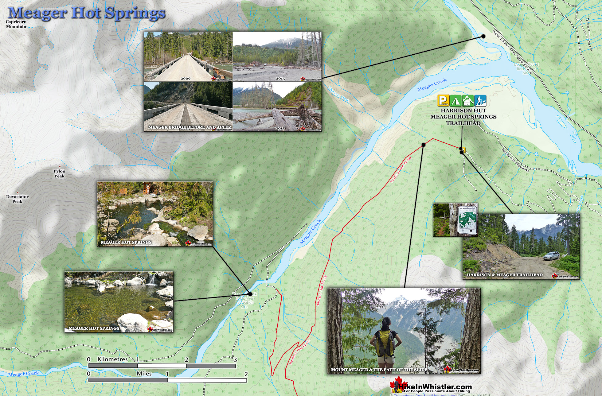
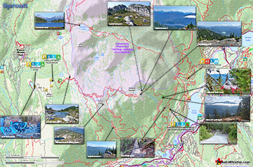
Only to be dramatically obliterated from another slide in 2010. In 2014 the new VOC Harrison Hut Trail was mostly completed, allowing access to Meager Hot Springs once again. Currently this access road is in a bit of a construction zone, so don't be surprised if the road is blocked by a rock slide or road construction.  The old access bridge over the Upper Lillooet River which cost nearly a million dollars was wrecked in seconds in 2010.  There was considerable wrangling and negotiating to get it built in in 2009, but now it will almost certainly never be rebuilt.  The area is far too active.  Access to the springs is now via the new Harrison Trail via the south side of the the Upper Lillooet River, above and beyond the still visible, still awe inspiring, mudslide carnage.  With the catastrophic mud and debris slide let loose from Devastator Peak in 2010, the nice new (in 2009) million dollar bridge to Meager Hot Springs was destroyed.  Though destroyed doesn't even begin to describe it. Looking on the now, dead end road, where the bridge once stood, the place still looks a mess. "Meager Creek FSR is closed indefinitely; no access to the hot springs." This is from the BCParks Upper Lillooet Provincial Park site, and evidently quite accurate.  Dead and still dying grey ghosts of trees still stand as they did in piles of forest wreckage.  Even the road in looks bizarre. The road was simply bulldozed back to life.  On either side, hemmed in by piles of dirt and dead trees.  The mudslide that did this seems beyond belief. This river valley in the midst of a beautiful, green forest, is a sea of brown.  Mud, dirt, and dead trees. At its peak of popularity in 1994, Meager Hot Springs had 30,000 visitors a year. With the unrestrained numbers, vandalism and violence broke out at the springs often so the BC Forest Service stepped in. They hired an on-site supervisor, limited vehicle access and charged a usage fee. Then the big slide of 2010 happened and now of course it only gets a few, very motivated visitors.  In the last couple years BC Ministry of Forests and Recreation Sites and Trails BC have been aggressively blocking public access to both Meager Hot Springs and Keyhole Hot Springs. Currently, in 2023 they have blocked both access roads with gates to the trailheads and are threatening to issue violation tickets. The warning reads: SITE CLOSED: Meager Hot Springs are within Lil̓wat Nation territory. This is a place of cultural and spiritual significance for Lil̓wat Nation. The site closure supports the protection of important cultural, environmental, and wildlife values. The Meager Creek Drainage is prone to extremely large landslides, avalanches, and flooding/washouts. The Province will be enforcing this closure and will issue violation tickets to anyone caught ignoring the restrictions. They don't appear to have any legitimate reasons for the closures and are clearly making up vague things to justify blocking public access. For example: "Mineral licks at the hot springs provide wildlife with year-round nutrients. The hot springs are also home to the vivid dancer damselfly, a species of special concern that is threatened by intensive recreational use. Meager Creek Hot Springs is the only known location within BC where the American bulrush (Schoenoplectus americanus) grows".

VOC Trail to Meager Creek Hot Springs

Meager Creek Hot Springs TrailIn 2014 a new route was built to Meager Creek Hot Springs by the UBC Varsity Outdoor Club. The new VOC Harrison Hut Trail regains access to the much prized Harrison Hut, but also opens up an excellent access trail to Meager. The trail is long and not too easy, however, and getting to the trailhead is quite an adventure. The logging road deteriorates quickly on the last couple kilometres and you find yourself dodging basketball sized boulders strewn across the road. The old access route to Meager ran along the far(north side) of the Lillooet Forest Service Rd. This new trailhead is located on the near(left or south) side of the Upper Lillooet River and you simply continue along the Pemberton Meadows Road (almost) until you can't go any further.  From the middle of Pemberton to the trailhead is 64 kilometres. The easy to miss trailhead is marked with a small trailhead sign for "VOC Harrison Hut Trail" No mention of Meager Creek Hot Springs on it.

Meager Hot Springs - Hike in Whistler

Meager Hot Springs Map v7

Meager Bridge Before and After

Driving to Meager Hot Springs Map v2

More Whistler & Garibaldi Park Hiking Maps!

Black Tusk Maps

Black Tusk is the extraordinarily iconic and appropriately named mountain that can be seen from almost everywhere in Whistler.  The massive black spire of crumbling rock juts out ...
Read more

Nairn Falls Maps

Nairn Falls is a wonderful, crashing and chaotic waterfall that surrounds you from the deluxe viewing platform that allows you to safely watch it from above.  The beautiful, green ...
Read more

Alexander Falls Maps

Alexander Falls is a very impressive 43 metre/141 foot waterfall just 30 to 40 minutes south of Whistler in the Callaghan Valley. Open year-round and located just before ...
Read more

Brandywine Falls Maps

Brandywine Falls is one of the must see sights on the way to or from Whistler. The falls drop from a 70 metre(230 feet), unnaturally abrupt looking cliff to the valley below. ...
Read more
More Whistler Hiking Trail Maps

Best West Coast Trail Guide 

Whistler & Garibaldi Park Glossary A to Z

Bushwhack is a term often used in Canada and the United States to refer to hiking off-trail where no trail exists.  Literally means 'bush' and 'whack'.  To ...
Read more
Whistler can be expensive.  Everything worth doing seems to cost a lot of money.  But if you step back from the noise and crowds you may spot some secret ...
Read more
Hoary Marmots are the cute, pudgy, twenty plus pound ground squirrels that have evolved to live quite happily in the hostile alpine areas around Whistler.  ...
Read more
The Garibaldi Ranges are a subdivision of the Pacific Ranges of the Coast Mountains.  Deriving its name from Mount Garibaldi, the Garibaldi Ranges cover the huge ...
Read more
The Spearhead Range is a subsection of the Garibaldi Ranges that runs in an arc that connects Whistler Mountain and Blackcomb Mountain.  The Spearhead ...
Read more
Whistler Bungee Bridge, also known as the Cheakamus Bungee Bridge is a very convenient and beautiful attraction on the way to or from Whistler from ...
Read more
Deadfall means a tangled mass of fallen trees and branches.  There are several name variations for fallen trees that are commonly used in Whistler.  ...
Read more
Moraines are glacially deposited ridges of debris that accumulate at the sides or terminus of a glacier.  Lateral moraines form at the sides of glaciers ...
Read more
More Hike in Whistler Glossary

Camping Gear Rental Whistler and Garibaldi Park

The Best Whistler & Garibaldi Park Hiking Trails!

The Sproatt East trail is a beautifully wild, steep, but relatively short trail to the magnificent, wide open alpine and summit of Mount Sproatt.  Mount Sproatt (1834 metres) towers over Whistler Valley ...
Read more
Hiking and biking trails are so abundant in Whistler that many go unnoticed, neglected or taken for granted.  The Flank Trail is one of these.  Most people in Whistler don't even know about it, but the ones ...
Read more
Logger's Lake is an amazing little lake hidden up in the deep forest above the more well known Cheakamus River. The lake, almost unbelievably exists in a long extinct volcano. However, as soon as you see ...
Read more
Taylor Meadows is a very scenic campsite and great alternative to the much busier and more well known, Garibaldi Lake campsite. Located in Garibaldi Provincial Park between Garibaldi Lake and Black Tusk, ...
Read more
More Whistler Hiking Trails & Maps

HikeInWhistler.com HikeInWhistler.com © 2026
  • Contact Us: [email protected]