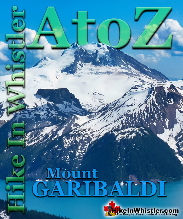
Mount Garibaldi is the huge, potentially active volcano that Garibaldi Provincial Park is named after. Mount Garibaldi also lends its name to the Garibaldi Ranges, the group of mountain ranges that fill Garibaldi Park. A subsection of the Garibaldi Ranges is the Garibaldi Névé, which is the large icefield that stretches out along the east side of Mount Garibaldi.
Whether you are standing in Squamish or high up on Panorama Ridge, Mount Garibaldi towers in the distance. From a wonderful vantage point such as Brandywine Meadows high up in the mountains across the valley, Mount Garibaldi appears monstrously huge. It is easy to imagine it bursting to life as an active volcano, which it technically still is. Named after a 19th century patriot and soldier, Giuseppe Garibaldi, Mount Garibaldi is a massive 2678 metre giant at the southern end of the park. It was named after Garibaldi by Captain George Henry Richards of the Royal Navy in 1860. Guiseppe Garibaldi had gained worldwide acclaim that year by unifying Italy by repatriating Sicily and Naples. In 1907 a group of Vancouver climbers reached the summit of Mount Garibaldi and marvelled at the view. In particular, Garibaldi Lake and Black Tusk caught their interest. Several forays into the area followed and a regular hiking camp was established between Black Tusk and Garibaldi Lake. In 1920 the Garibaldi Park Reserve was established and in 1927 Garibaldi Provincial Park was born.
Mount Garibaldi From Panorama Ridge
Mount Garibaldi, The Table and Mount Price
Garibaldi's Peaks
Garibaldi has two peaks in addition to the highest peak that is referred to as Mount Garibaldi , with an elevation of 2678 metres/8786 feet. The next highest peak is Atwell Peak on the southern edge of the summit plateau, with an elevation of 2655 feet/8711 feet. Atwell Peak is named after Atwell King, who led the first recorded ascent of Mount Garibaldi in 1907. One of the guides in the party, Arthur Tinniswood Dalton, has the third highest peak of Mount Garibaldi named after him. Dalton Dome is located on the west of the main summit and sits at an elevation 2653 metres/8704 feet and can be distinguished by its rounded shape. Other minor summits on Mount Garibaldi include, The Tent at 2465 metres/8087 feet, Diamond Head at 2056 metres/6745 feet, and so named because of its resemblance to Hawaii's Diamond Head.
Mount Garibaldi From Alice Lake
Mount Garibaldi From Black Tusk
Mount Garibaldi From Brandywine Meadows
More Whistler & Garibaldi Park Hiking A to Z!
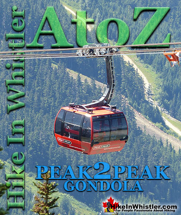
The Peak 2 Peak Gondola connects Whistler Mountain and Blackcomb Mountain at a dizzying height of 436 metres(1427 feet). It runs all winter and in the ...
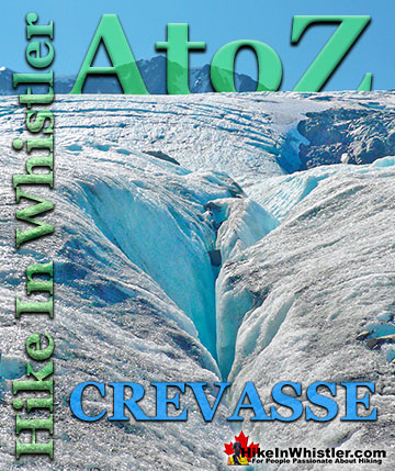
Crevasse: is a split or crack in the glacier surface, often with near vertical walls. Crevasses form out of the constant movement of a glacier over ...
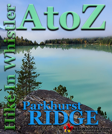
Parkhurst Ridge is an incredible place for a lot of reasons. Of course, the view is spectacular with Green Lake's absurdly vivid green coloured water. ...
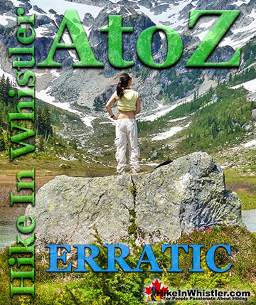
Erratic or glacier erratic is a piece of rock that has been carried by glacial ice, often hundreds of kilometres. Characteristic of their massive size and ...
The Green Lake Loop is the original trail that runs around the back side of Green Lake. Before the Sea to Sky Highway was cut through the valley in 1964, ...
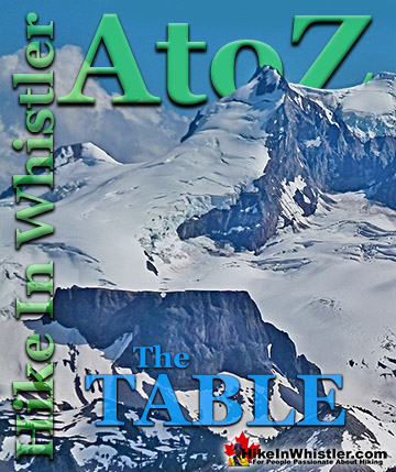
The Table is an extraordinary flat-topped mountain located in Garibaldi Park just one kilometre south of Garibaldi Lake. Sometimes reflexively referred to as ...
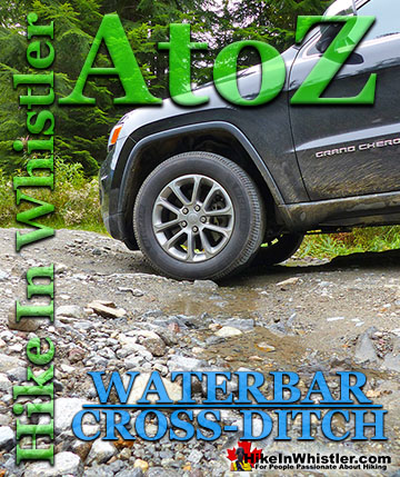
Waterbar and Cross-Ditch: the purpose of a waterbar or cross-ditch is to capture and redirect surface water from the road and channel it across the road ...
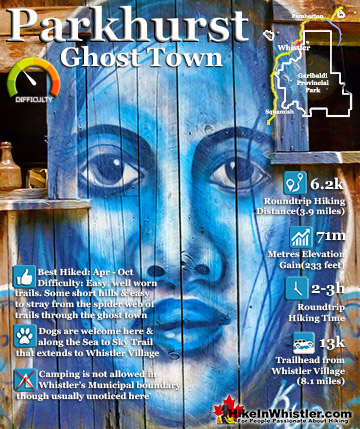
Whistler has an absurd number of wonderful and free hiking trails and Parkhurst Ghost Town certainly ranks as the most unusual and interesting. Parkhurst was a little logging town perched on the edge of Green ...
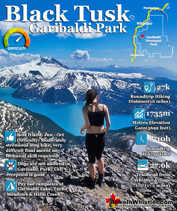
Black Tusk is the extraordinarily iconic and appropriately named mountain that can be seen from almost everywhere in Whistler. The massive black spire of crumbling rock juts out of the earth in an incredibly ...
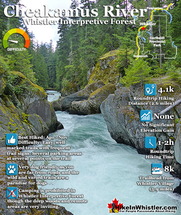
Cheakamus River is a beautiful, crashing, turquoise coloured river that flows from Cheakamus Lake, through Whistler Interpretive Forest, then down past Brandywine Falls to Daisy Lake, then all the way to ...
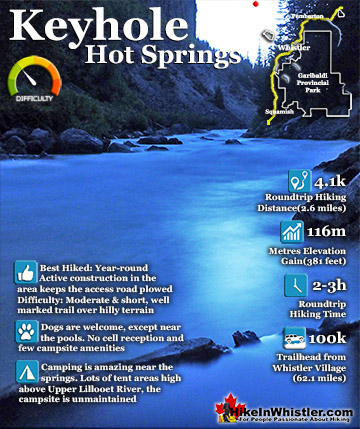
Keyhole Hot Springs (aka Pebble Creek Hot Springs) is located 100 kilometres from Whistler (Village Gate Blvd). Though much of the drive to Keyhole is on logging roads, the route is driveable by most cars ...
July is a wonderful time to hike in Whistler and Garibaldi Provincial Park. The weather is beautiful and the snow on high elevation hiking trails is long ...
August hiking in Whistler definitely has the most consistently great, hot weather. You can feel the rare pleasure of walking across a glacier shirtless and ...
September hiking in Whistler is possibly the best month of all. The snow has melted far up to the mountain tops, yet the temperatures are still quite ...
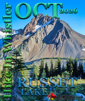
Hiking in Whistler in October is often unexpectedly stunning. The days are much shorter and colder but the mountains are alive with colour from the fall ...
Hiking in Whistler is spectacular and wonderfully varied. Looking at a map of Whistler you see an extraordinary spider web of hiking trails that are unbelievably numerous. Easy trails, moderate trails and challenging hiking trails are all available. Another marvellous ...
Squamish is located in the midst of a staggering array of amazing hiking trails. Garibaldi Provincial Park sprawls alongside Squamish and up and beyond Whistler. Tantalus Provincial Park lays across the valley to the west and the wonderfully remote Callaghan Valley ...
Vancouver is surrounded by seemingly endless hiking trails and mountains to explore. Massive parks line up one after another. Mount Seymour Provincial Park, Lynn Canyon Park, Grouse Mountain, Cypress Park and the enormous Garibaldi Park all contribute to Vancouver ...
Clayoquot Sound has a staggering array of hiking trails within it. Between Tofino and Ucluelet, Pacific Rim Park has several wilderness and beach trails, each one radically different from the last. The islands in the area are often Provincial parks on their own with ...
Victoria has a seemingly endless number of amazing hiking trails. Most take you to wild and beautiful Pacific Ocean views and others take you to tranquil lakes in beautiful BC Coastal Rainforest wilderness. Regional Parks and Provincial Parks are everywhere you turn ...
The West Coast Trail was created after decades of brutal and costly shipwrecks occurred along the West Coast of Vancouver Island. One shipwreck in particular was so horrific, tragic and unbelievable that it forced the creation of a trail along the coast, which ...