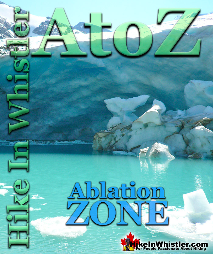
![]() Ablation Zone: the lower altitude region of a glacier where there is a net loss of ice mass due to melting, sublimation, evaporation, ice calving or avalanche. The ablation zone of a glacier such as the Wedgemount Glacier has meltwater features such as englacial streams and a glacier window. An englacial stream refers to meltwater flowing inside a glacier. A glacier window is a cave-like opening at the mouth of a glacier where meltwater runs out.
Ablation Zone: the lower altitude region of a glacier where there is a net loss of ice mass due to melting, sublimation, evaporation, ice calving or avalanche. The ablation zone of a glacier such as the Wedgemount Glacier has meltwater features such as englacial streams and a glacier window. An englacial stream refers to meltwater flowing inside a glacier. A glacier window is a cave-like opening at the mouth of a glacier where meltwater runs out.
Whistler & Garibaldi Hiking
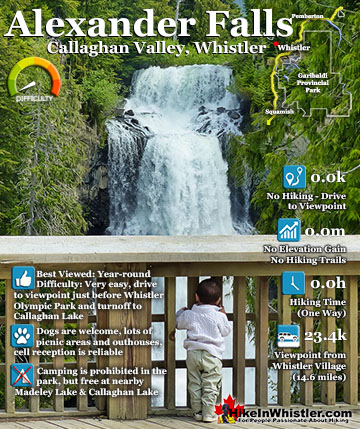
![]() Alexander Falls
Alexander Falls ![]() Ancient Cedars
Ancient Cedars ![]() Black Tusk
Black Tusk ![]() Blackcomb Mountain
Blackcomb Mountain ![]() Brandywine Falls
Brandywine Falls ![]() Brandywine Meadows
Brandywine Meadows ![]() Brew Lake
Brew Lake ![]() Callaghan Lake
Callaghan Lake ![]() Cheakamus Lake
Cheakamus Lake ![]() Cheakamus River
Cheakamus River ![]() Cirque Lake
Cirque Lake ![]() Flank Trail
Flank Trail ![]() Garibaldi Lake
Garibaldi Lake ![]() Garibaldi Park
Garibaldi Park ![]() Helm Creek
Helm Creek ![]() Jane Lakes
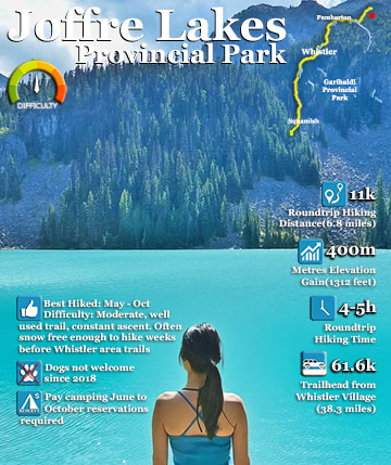
Jane Lakes ![]() Joffre Lakes
Joffre Lakes ![]() Keyhole Hot Springs
Keyhole Hot Springs ![]() Logger’s Lake
Logger’s Lake ![]() Madeley Lake
Madeley Lake ![]() Meager Hot Springs
Meager Hot Springs ![]() Nairn Falls
Nairn Falls ![]() Newt Lake
Newt Lake ![]() Panorama Ridge
Panorama Ridge ![]() Parkhurst Ghost Town
Parkhurst Ghost Town ![]() Rainbow Falls
Rainbow Falls ![]() Rainbow Lake
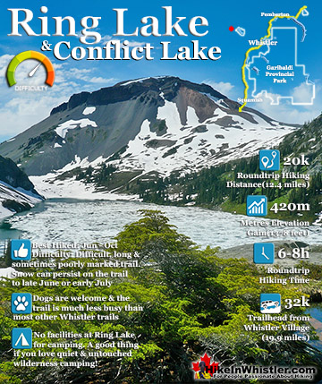
Rainbow Lake ![]() Ring Lake
Ring Lake ![]() Russet Lake
Russet Lake ![]() Sea to Sky Trail
Sea to Sky Trail ![]() Skookumchuck Hot Springs
Skookumchuck Hot Springs ![]() Sloquet Hot Springs
Sloquet Hot Springs ![]() Sproatt East
Sproatt East ![]() Sproatt West
Sproatt West ![]() Taylor Meadows
Taylor Meadows ![]() Train Wreck
Train Wreck ![]() Wedgemount Lake
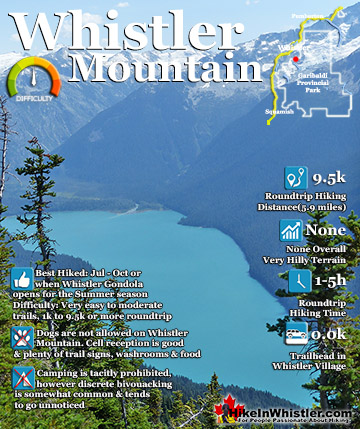
Wedgemount Lake ![]() Whistler Mountain
Whistler Mountain
![]() January
January ![]() February
February ![]() March
March ![]() April
April ![]() May
May ![]() June
June ![]() July
July ![]() August
August ![]() September
September ![]() October
October ![]() November
November ![]() December
December
A glacier such as the Wedgemount Glacier which stretches from Wedge Mountain down toward Wedgemount Lake, the ablation zone is quite beautiful. A big pool of meltwater spills down the rock face and into turquoise coloured Wedgemount Lake. The pool of water is at the toe of Wedgemount Glacier and the large glacier window appears like a huge, gaping mouth. Big chunks of ice float in the pool and chunks of glacier split off into the water. The Wedgemount Glacier has been receding for decades. In the 1970's the glacier terminated with a steep and vertical wall of ice at the shores of the lake. Today the glacier terminates several hundred metres above Wedgemount Lake. Of the many accessible glaciers around Whistler in Garibaldi Provincial Park, the Wedgemount Glacier is possibly the most impressive. The trailhead for Wedgemount Lake is located near the north end of Green Lake, just 10 minutes north of Whistler Village. Wedgemount Lake is a beautiful turquoise, glacier coloured lake lake that is nestled in a gorgeous and hostile looking rocky valley surrounded by mountains. Rethel Mountain, Parkhurst Mountain, Wedge Mountain, Mount Weart, Armchair Glacier and Mount Cook surround the lake with Wedgemount Glacier filling the valley between Parkhurst and Weart and flowing down from the highest mountain in Garibaldi Park.
The Ablation Zone of Wedgemount Glacier
The ablation zone of Wedgemount Glacier shown here in the summer with the englacial stream pooling in front of the glacier window. The Wedgemount Glacier is one of the most easily accessible glaciers around Whistler. Though the seven kilometre trail to Wedgemount Lake is fairly steep, it is relatively short. Without a heavy backpack a fit person can hike the trail in well under two hours. With a heavy pack expect to take over two hours.
Wedgemount Glacier Ablation Zone

Once at the lake you will see a faint trail lead down and around the far end of the lake and up to the ablation zone and the dramatically beautiful glacier window. Though the shape and size of the glacier window varies from year to year, it is always a magnificent sight to see up close.
The Glacier Window on Wedgemount Glacier

View from Above the Glacier Window

Wedgemount Glacier Ablation Zone

Wedgemount Glacier's Ablation Zone & Glacier Window

Aerial View of Wedgemount Glacier

Wedgemount Glacier's Englacial Stream
One of the nicest places to see Wedgemount Lake is from the edge of the englacial stream that tumbles over the final rocky slope to the turquoise, glacier coloured water. At the far end of the lake the water flows out via Wedgemount Falls to Wedgemount Creek and down the valley to Green River.
Wedgemount Glacier's Englacial Stream

Sights to See Around Wedgemount Lake
Though Wedgemount Glacier is an impressive sight, Wedgemount Lake, with its captivating colour is the main attraction. The extraordinary turquose colour of the lake contrasts well with the dark and menacing Rethel Mountain towering above. Hiking to the ablation zone of Wedgemount Glacier is just one of many beautiful sights to see. There are a few excellent and secluded places along the shore perfect to jump into the always bitterly cold water. You can hike the short route to get close to the top of Wedgemount Falls. On the way you pass over the hill at the end of the lake with great views. Back down at the ablation zone of Wedgemount Glacier you can hike up onto the glacier and make your way up to the Wedge-Weart Col that separates these two mighty peaks.
Beautiful Wedgemount Lake

Rethel Mountain
Rethel Mountain towers over Wedgemount Lake and meets the abrupt end of the lake where it flows out and down Wedgemount Falls. The Wedgemount Lake side of Rethel Mountain is north facing and therefore always in the shade, making its already dark form almost pure black, especially near sunset.
Rethel Mountain Towers Above Wedgemount Lake

Wedgemount Falls
Wedgemount Falls drops about 300 metres down an almost vertical cliff from Wedgemount Lake. There is one spot along the trail to Wedgemount Lake that you catch sight of it and it never fails to catch you by surprise. Concealed by trees, you hear it long before you catch sight of it. When you finally get a glimpse of it between the trees, you can't help but be shocked at how close it looks, despite being quite far away still.
Wedgemount Falls from the Wedgemount Lake Trail

Swimming in Wedgemount Lake With Icebergs
Often Wedgemount Lake is frozen well into June and early July. The rest of the summer it is not unusual to see icebergs floating in the lake. Despite the obvious bitterly cold temperature of the water even on a 22c day in July, it is hard not to jump in the lake. From the hut, if you walk directly towards the lake and bear right when possible you will come to a couple perfect places to jump in.
Wedgemount Lake Iceberg in July!

Relatively smooth rock outcrops can be found along the shore and you usually can't see the bottom of the lake around them. As the water is close to freezing even on the hottest days of the year, jumping in is preferable to walking in from the shore down at the other end of the lake in front of the tent platforms. As you hit the water your entire body instantly numbs from the cold and you can't help but scramble out of the water and back into the sun on the warm rock.
One Great Place to Swim in Wedgemount Lake

The views from this perfect swimming rock are sensational. Across the lake and to the left you see Parkhurst Mountain (pictured above) and to your right you look toward the end of the lake with Rethel Mountain towering above (pictured below).
A Spectacular Spot to Swim in Wedgemount Lake

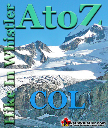
The Wedge-Weart Col
The Wedge-Weart Col is possibly the easiest hike from Wedgemount Lake. It is a long scramble through the boulder strewn terrain to the Wedgemount Glacier, then a long ascent up Wedgemount Glacier. It is deceptively far so allow at least 4 hours roundtrip from the Wedge Hut.
Mount James Turner from the Wedge-Weart Col

Below is a picture taken from the Wedge-Weart Col looking south with Parkhurst Mountain in the middle and Rethel Mountain on the right.
Wedge-Weart Col View of Parkhurst Mountain and Rethel Mountain

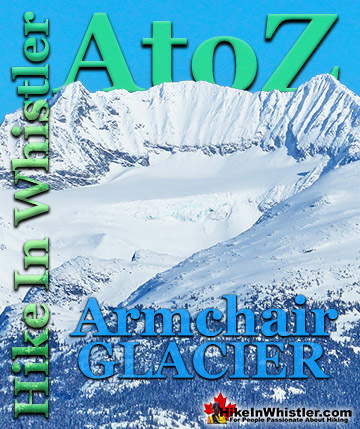
Mount Cook & Armchair Glacier
Mount Cook is a relatively easy hike from Wedgemount Lake. It is partly marked and a worn trail leading to a scramble up the logical ascent of Mount Cook. You get tremendous views of Wedgemount Lake and surrounding mountains from the summit. Armchair Glacier is adjacent to Mount Cook and catches your attention far more than the unassuming Mount Cook.
Armchair Glacier on the Hike to Mount Cook

Camping at Wedgemount Lake
If you are camping overnight, you will pass several rustic, gravel tent clearings directly opposite the glacier and just steps from the lake. Up towards the hut there are several wooden tent platforms for tents as well. No matter where you set up your tent you have a breathtaking view of this alpine paradise.
Waterfront Tent View of Wedgemount Glacier

Up in the midst of the boulder field near the Wedge Hut you will find several more beautiful tent platforms overlooking the lake. From there you get a much better view of the Wedgemount Lake, Wedgemount Glacier and the surrounding mountains. The picture below is a typical sunset tent view of Wedgemount Lake.
Boulder Field Tent View of Spectacular Wedgemount Lake

Wedgemount Lake Maps
Below is a map showing Wedgemount Lake from several vantage points. The upper tent pad view looking across to Wedgemount Glacier, an iceberg in July, the beautiful glacier window, the amazing view from the lower tent pads along Wedgemount Lake. The map also shows the various routes up Wedgemount Glacier to Wedge Mountain. These routes are potentially very dangerous and glacier travel is always unpredictable and hazardous, so make sure you know what you are doing before venturing beyond the glacier window.

Ablation Zone at Joffre Lakes
Another great place to get up close to see an ablation zone of a glacier is at Joffre Lakes. There is a glacier window found above Upper Joffre Lake that most visitors to the lakes don't bother to hike to. It is just a five minute hike up the rocky slope that stretches above the campsites. Here you find a small glacier window and a lot of glacier water flowing out. Not as impressive at the one at Wedgemount Lake, though the area is pretty nice to explore, and the view of Joffre Lakes is magnificent. There are also so great rock outcrops that are warm and sunny places to lounge in the summer.
Matier Glacier Ablation Zone and Glacier Window at Joffre Lakes


Guides to the Best of Whistler
 Best Dog Friendly Hiking Trails
Whistler is very dog friendly and the number of wonderful hiking trails that your dog will love is huge. The massively varied hiking trails range from easy, short, close to Whistler Village to challenging, long and deep in the endless wilderness around Whistler. You can find dog friendly trails in and around Whistler Village that take you through deep, dark and magical forests. Or you can drive beyond Whistler Village and take your dog to spectacular alpine lakes. Some requiring little or no hiking, while others are found after hiking challenging and long trails. Many of these places are comparatively quiet and often you and your dog will have the the wilderness to yourselves. In and around Whistler Village you have Lost Lake with its spider web of trails... Continued here.
 Best Free Whistler Camping
Whistler is surrounded by an immense wilderness dotted with spectacular, hidden lakes and amazing places to set up a tent. Decades of logging activity has left a network of forest service roads that has opened easy access to these places. Some of these you can drive to and some you may need a 4x4 to comfortably get to. Some places to camp for free you can drive to, some require a short hike and others are fairly long hikes to reach. Beautiful Callaghan Valley is home to several incredible and free places to camp. Callaghan Lake has a great free drive-to campsite just steps from this spectacular alpine lake. If you have a canoe, you can paddle to the end of Callaghan Lake and hike the short, but steep trail up to Cirque Lake. This gorgeous lake is deep in the alpine wilderness... Continued here.
 No Car? No Problem! Whistler Trails
Whistler as a resort has a wonderful car-free core. The Village Stroll runs through the heart of Whistler Village and is entirely car free. If you are visiting Whistler or living here and you don't have a car, it's no problem. On foot or on a bike you can travel the extensive network of non-motorized trails. The Valley Trail snakes through Whistler Village and extends in several directions, all of which lead to beautiful parts of Whistler. The Sea to Sky Trail and the Lost Lake trails continue this massive, car-free network of trails running almost everywhere in Whistler. When it comes to many of the best hiking trails, getting to the trailheads on foot, by bike or public transit can be tricky at best or complicated and impractical at worst. Many trailheads are far from Whistler Village and... Continued here.
More Whistler & Garibaldi Park Hiking A to Z!

The Best Whistler & Garibaldi Park Hiking Trails!
Whistler & Garibaldi Park Best Hiking by Month!


Explore BC Hiking Destinations!

Whistler Hiking Trails

Squamish Hiking Trails

Vancouver Hiking Trails

Clayoquot Hiking Trails
Victoria Hiking Trails

