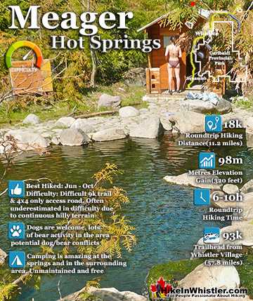
![]() Whistler has an absurd number of wonderful and free hiking trails and Parkhurst Ghost Town certainly ranks as one of the most unusual, exotic and interesting. Parkhurst was a little logging town perched on the edge of Green Lake way before Whistler was Whistler. Up on the ridge where Parkhurst sits, the views are sensational. Green Lake far below, a solid unnatural looking mass of green.
Whistler has an absurd number of wonderful and free hiking trails and Parkhurst Ghost Town certainly ranks as one of the most unusual, exotic and interesting. Parkhurst was a little logging town perched on the edge of Green Lake way before Whistler was Whistler. Up on the ridge where Parkhurst sits, the views are sensational. Green Lake far below, a solid unnatural looking mass of green.
 Several routes to get there
- Interesting old relics everywhere
- Many gorgeous places to camp
- Seemingly endless network of trails
- Famous Toad Hall house was here!
- Stunning views of Green Lake
- Many hidden places to explore
- Relatively quiet place to hike
- Easy access by boat
 Trails are unmarked and confusing
Blackcomb Mountain and Whistler Mountain out in the distance to the left and Rainbow Mountain across and beyond the lake. If you have a good look around Parkhurst today, you can find remnants of its past almost everywhere you look. From the old disintegrating truck from the 50's to the absurdly and improbably located car being consumed by the forest. What makes Parkhurst Ghost Town such a great hiking trail and destination is where it is located and the trail to get to it. One route, one of several ways to get to it, runs along the scenic Green River and next to the still active train tracks that run through Whistler. There always seems to be something to see. From the beautiful meadow along the train tracks, to the suddenly deep forest where you have to play a game of finding the next, pink tree marker or risk wandering off the trail. The trail markers are numerous, and though getting lost is inevitable, you can only stray a few metres before, the river or steep terrain push you back onto the marked trail. Once up on the ridge above Green Lake where Parkhurst is located, the forest takes on a spooky feel. Trees are all far apart and with branches only high up give the forest a unnaturally lifeless look. As recent as the late 90's a few houses remained standing, but the merciless winters with crushing snow has collapsed all but one house. There are a couple half collapsed relics, but for the most part the town has disintegrated. Unexpectedly, even in the deep snow of winter, stumbling on remnants of the old town are frequent. Countless half collapsed houses lay in the picturesque forest that has grown since the town was abandoned.

Finding the abandoned vehicles in the town is like a game as you wander around the maze of trails. The old rusty car, the even older truck, and an ancient and enormous logging tractor perched as it was decades ago, on the edge of Green Lake. Quite a marvel to see. Like a giant museum exhibit that looks like it could still be there in a thousand years from now.

Just steps from the impressive tractor, if you are lucky and persistent, you can find another extraordinary part of abandoned tractor. This huge and solid piece of steel, left so long ago, has had trees grow in and around it. A large tree, over 50 years old now grows in a triangle shape through this ancient machinery. Squeezing into the only shape it could, but bewildering to see. If you do find it you will probably circle it over and over, trying to figure out how it managed to grown its way through.

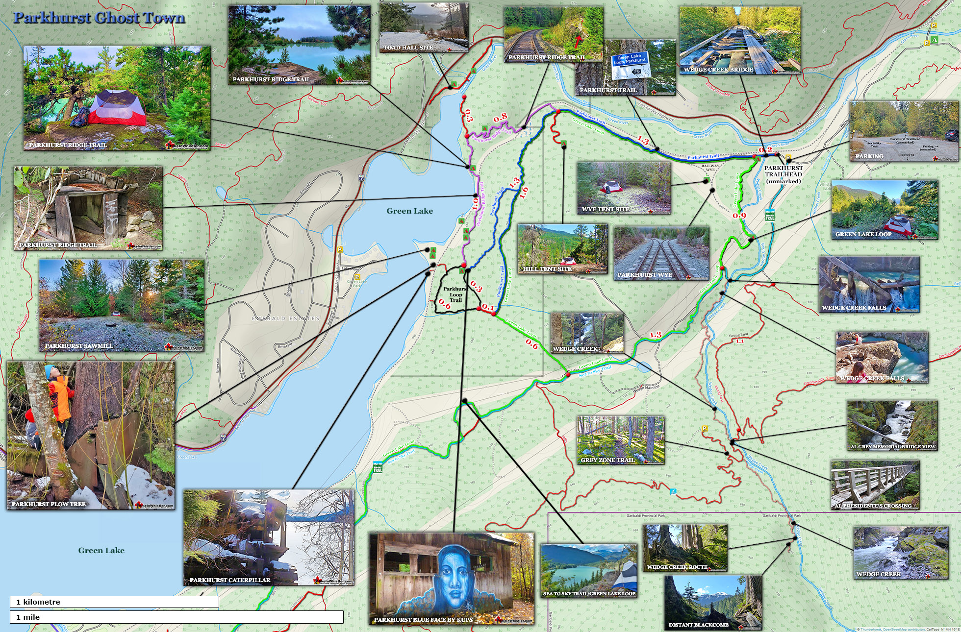
Parkhurst Ghost Town Map
The small logging town called Parkhurst came into being in 1926 when the Barr Brothers Logging Company purchased the land from a recent widow looking to sell. Mrs. Parkhurst sold the land and a small house which quickly transformed into several small houses, bunkhouses and a steam powered mill on the point of land that still conspicuously juts out from the shore. Soon there were 70 loggers working the mill and living much of the year in the town that was now named after the original owners of the land, the Parkhurst's.

The Great Depression hit the logging industry hard and unable to sell what they produced and the mill went into receivership. In 1932 the mill was purchased by another logging company and was back in business under a new name, Northern Mills. It was to be short lived however, as a fire destroyed the mill in 1938. It was rebuilt and the town once again grew in size to include a school and a store. Parkhurst continued as a small logging town until the logging industry slowed down in the 1950's and in the 1956 Parkhurst was finally abandoned.


The History of Parkhurst Ghost Town
![]() The small logging town called Parkhurst came into being in 1926 when the Barr Brothers Logging Company purchased the land from a recent widow looking to sell. Mrs. Parkhurst sold the land and a small house which quickly transformed into several small houses, bunkhouses and a steam powered sawmill on the point of land that still conspicuously juts out from the shore. Soon there were 70 loggers working the mill and living much of the year in the town that was now named after the original owners of the land, Parkhurst. The Great Depression hit the logging industry hard and unable to sell what they produced and the mill went into receivership. In 1932 the mill was purchased by another logging company and was back in business under a new name, Northern Mills. It was to be short lived however, as a fire destroyed the mill in 1938. It was rebuilt and the town once again grew in size to include a school and a store. Parkhurst continued as a small logging town until the logging industry slowed down in the 1950's and in 1956 Parkhurst was finally abandoned.
The small logging town called Parkhurst came into being in 1926 when the Barr Brothers Logging Company purchased the land from a recent widow looking to sell. Mrs. Parkhurst sold the land and a small house which quickly transformed into several small houses, bunkhouses and a steam powered sawmill on the point of land that still conspicuously juts out from the shore. Soon there were 70 loggers working the mill and living much of the year in the town that was now named after the original owners of the land, Parkhurst. The Great Depression hit the logging industry hard and unable to sell what they produced and the mill went into receivership. In 1932 the mill was purchased by another logging company and was back in business under a new name, Northern Mills. It was to be short lived however, as a fire destroyed the mill in 1938. It was rebuilt and the town once again grew in size to include a school and a store. Parkhurst continued as a small logging town until the logging industry slowed down in the 1950's and in 1956 Parkhurst was finally abandoned.

 When Whistler Mountain opened as a ski resort in the winter of 1965/66 and Highway 99 was constructed thousands of skiers flocked to Whistler. Transient skiers discovered Parkhurst and lived in some of the remaining houses. Ski bums inhabited every available space to sleep in Whistler and gave birth to the legendary Toad Hall on Alta Lake. Toad Hall, a rented house, became a party house that gained a reputation known Canada wide. In 1969, when the owners discovered what was happening they evicted the residents and demolished the house. Within months, Toad Hall was resurrected near Parkhurst at the north end of Green Lake. The Soo Valley Logging Company had recently vacated their logging camp and it was taken over by skiers. This second incarnation of Toad Hall became the one famously memorialized in the photo of the naked skiers. The famous photo was taken shortly before the logging camp buildings were demolished.
Timeline of Parkhurst:
1902: The Parkhurst’s pre-empted a parcel of land along the shore of Green Lake. Little is known about the Parkhurst’s except they built a small house there and raised a family.
1926: After Mr. Parkhurst passed away, the Parkhurst’s sold their property to the Barr brothers of Mission, BC. William, Malcolm and Ross Barr moved their lumber operation to the Parkhurst land. They constructed a sawmill and some houses for workers and named it the Parkhurst Mill.
1928: Malcolm Barr drowned in Green Lake when he fell from a boat while working logs on the lake.
1930: The Parkhurst Mill did well for the first three years of operation until the Great Depression hit and demand for lumber evaporated. Unable to even cover the costs of transporting the lumber, the Parkhurst Mill went into receivership. With the mill closed and all the workers gone, the receiver hired Ross Barr and his wife to watch over the mill until a buyer could be found. They were paid just $50 per month and a barrel of coal oil to burn in their lamps.
1932: Parkhurst was purchased by B.C. Keeley and Byron Smith.
1933: in 1933 the Parkhurst Mill was reopened under the name Norther Mills. Ross Barr was hired along with Denis DeBeck to manage the new mill.
1938: Northern Mills was destroyed by fire and what could be salvaged was moved to the north end of Lost Lake and rebuilt there.
1939: The mill was moved back to Parkhurst as the Lost Lake location was too far from the railroad to be feasible. The new mill at Parkhurst was rebuilt and operations resumed. Parkhurst grew in size as the mill prospered once again.
1948: The Kitteringham family (Olie, Eleanor and their children Ron, Jim and Linda) lived at Parkhurst from 1948 until the mill shut down in 1956. During that time Parkhurst employed about 30 men, including millwright Olie. For the first few years the Kitteringhams were the only family to stay at Parkhurst through the winter. They made extra money shovelling the snow off the mill’s buildings so that they wouldn’t collapse in the spring when the rains made all that snow very heavy.
1956: The mill at Parkhurst closed and the town was abandoned.
1966: Highway 99 was completed to Pemberton and Whistler Mountain opened for skiing in the winter of 1965/66. The sudden influx of visitors to Whistler led to the remaining houses in Parkhurst being occupied by skiers. On Alta Lake a rental house began its transformation into what would famously become known as Toad Hall.
1969: RCMP issued a court order to the residents of Toad Hall on Alta Lake to be evicted and the building demolished. The residents of Toad Hall threw one last farewell party before leaving. Soon after the second incarnation of Toad Hall developed in the abandoned Soo Valley Logging Camp at the northern end of Green Lake near Parkhurst.
1973: The second Toad Hall was scheduled for demolition in the summer of 1973. That spring, knowing their time there was nearing its end gathered for a photo in their ski gear and nothing else. Photographer Chris Speedie printed 10000 copies in poster size and sold for two or three dollars each. Terry “Toulouse” Spence sold copies along the World Cup ski circuit.
2013: Terry “Toulouse” Spence brought a box of the original posters to Whistler Museum. The museum sold the remaining posters from the original 10000 and was able to proudly boast that the original run of the Toad Hall poster sold out almost 45 years after it was first printed. Reprints of the original Toad Hall poster are currently available for purchase at the museum.
2017: Resort Municipality of Whistler purchased the Parkhurst lands (200acres/81 hectares), including the land where the famous Toad Hall picture was taken. The intent is to preserve the historic land and remaining features into a park, however it is likely to remain mostly unchanged for the foreseeable future. The aerial image below shows the land purchased by the RMOW in 2017 and below that a map showing the land purchased.

Parkhurst Land Purchase Map 2017
The red line on the map the land purchased by the Resort Municipality of Whistler in 2017.

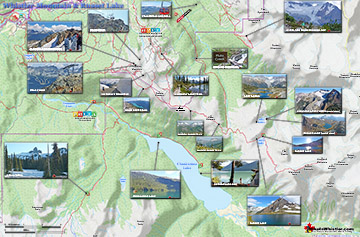
Parkhurst Ghost Town Wider Area Map
This map of Parkhurst Ghost Town shows the wider area extending to Lost Lake where the Sea to Sky Trail and Green Lake Loop Trail connect it to Whistler Village.

Parkhurst Ghost Town Loop Trail Map
This map of Parkhurst Ghost Town shows the Parkhurst Loop Trail in more detail. The Parkhurst Loop Trail is the popular route around where most of the houses once stood and are now mostly flattened.

Parkhurst Ghost Town Sawmill Map
The old Parkhurst sawmill is long gone, however more than six centuries have transformed the area into a wonderful hidden world to explore. It is hard to penetrate through the tangle of trees and bushes that surround it, but if you manage to bushwhack through you will find some remarkable sights. The Plow Tree is a bizarre interaction between a huge tree and a solid metal plow. Nearby the relentless undergrowth is actually lifting another massive plow which is still attached to an old Caterpillar tractor. Further into the old Parkhurst sawmill site you will see remnants of the sheet metal roof of the sawmill flattened on the ground under a thick layer of forest floor. Mostly unseen the layer of metal that was once the roof of the mill and causeway can be roughly defined by the lack of large trees growing in certain areas.

Driving Directions Map to Parkhurst
There are several ways to access Parkhurst Ghost Town, but the access from the Wedgemount Lake turnoff on the Sea to Sky Highway is the most direct if arriving on foot or bike. If you zero your odometer at Village Gate Blvd in Whistler Village and drive north on Highway 99, at 11.9 kilometres you will see the Wedgemount(Garibaldi) turnoff on your right. Turn here, cross the train tracks and then the bridge over Green River, turn right and follow the gravel road for a few hundred metres. You will pass Whistler Paintball on your left and then see a yellow gate and a sign for the Sea to Sky Trail. Park on the clearing across from the yellow gate and walk straight ahead along the old gravel road, passing the yellow gate, road and Sea to Sky Trail on your left. Biking or hiking the 10 kilometres to Parkhurst from Whistler Village is a very nice option, though lots of steep hills makes it a tough trek for some. Biking from the Village takes about a half an hour if you are fast, and hour if you are slow, and follows the beautiful Sea to Sky Trail up around Green Lake. Hiking to Parkhurst from the Village will take the average hiker 2-3 hours each way. This map shows the driving directions to the unmarked Parkhurst Ghost Town trailhead near the north end of Green Lake. This trailhead gets you to Parkhurst much quicker and easier than the long trek from Whistler Village.
Parkhurst Ghost Town Driving Directions Map

A Lot More Parkhurst Ghost Town hiking info...
More Whistler & Garibaldi Park Hiking Maps!
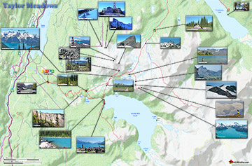
Taylor Meadows Maps
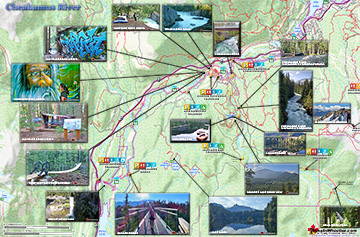
Cheakamus River Maps
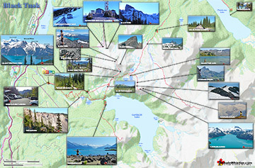
Black Tusk Maps
Russet Lake Maps

Whistler & Garibaldi Park Glossary A to Z

The Best Whistler & Garibaldi Park Hiking Trails!