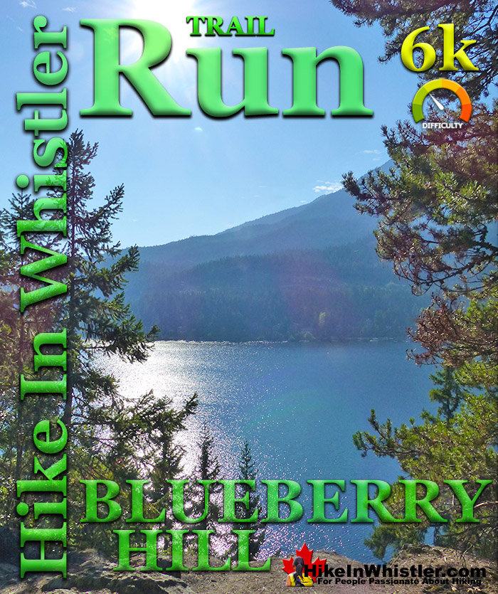
![]() The Blueberry Hill 6 kilometre(3.7 mile) trail run is a beautiful running route that is packed with great views and a wonderfully varied terrain. From Whistler Village you run along the edge of Whistler Golf Course on the wide, paved, two lane trail to the start of the Blueberry Trail. The Blueberry Trail quickly ascends through a deep forest as a few small switchbacks take you high up on the edge of Blueberry Hill. This five minutes of gruelling ascent then levels off and you get the first of several nice viewpoints, high above Alta Lake.
The Blueberry Hill 6 kilometre(3.7 mile) trail run is a beautiful running route that is packed with great views and a wonderfully varied terrain. From Whistler Village you run along the edge of Whistler Golf Course on the wide, paved, two lane trail to the start of the Blueberry Trail. The Blueberry Trail quickly ascends through a deep forest as a few small switchbacks take you high up on the edge of Blueberry Hill. This five minutes of gruelling ascent then levels off and you get the first of several nice viewpoints, high above Alta Lake.
Whistler & Garibaldi Hiking
![]() Alexander Falls
Alexander Falls ![]() Ancient Cedars
Ancient Cedars ![]() Black Tusk
Black Tusk ![]() Blackcomb Mountain
Blackcomb Mountain ![]() Brandywine Falls
Brandywine Falls ![]() Brandywine Meadows
Brandywine Meadows ![]() Brew Lake
Brew Lake ![]() Callaghan Lake
Callaghan Lake ![]() Cheakamus Lake
Cheakamus Lake ![]() Cheakamus River
Cheakamus River ![]() Cirque Lake
Cirque Lake ![]() Flank Trail
Flank Trail ![]() Garibaldi Lake
Garibaldi Lake ![]() Garibaldi Park
Garibaldi Park ![]() Helm Creek
Helm Creek ![]() Jane Lakes
Jane Lakes ![]() Joffre Lakes
Joffre Lakes ![]() Keyhole Hot Springs
Keyhole Hot Springs ![]() Logger’s Lake
Logger’s Lake ![]() Madeley Lake
Madeley Lake ![]() Meager Hot Springs
Meager Hot Springs ![]() Nairn Falls
Nairn Falls ![]() Newt Lake
Newt Lake ![]() Panorama Ridge
Panorama Ridge ![]() Parkhurst Ghost Town
Parkhurst Ghost Town ![]() Rainbow Falls
Rainbow Falls ![]() Rainbow Lake
Rainbow Lake ![]() Ring Lake
Ring Lake ![]() Russet Lake
Russet Lake ![]() Sea to Sky Trail
Sea to Sky Trail ![]() Skookumchuck Hot Springs
Skookumchuck Hot Springs ![]() Sloquet Hot Springs
Sloquet Hot Springs ![]() Sproatt East
Sproatt East ![]() Sproatt West
Sproatt West ![]() Taylor Meadows
Taylor Meadows ![]() Train Wreck
Train Wreck ![]() Wedgemount Lake
Wedgemount Lake ![]() Whistler Mountain
Whistler Mountain
![]() January
January ![]() February
February ![]() March
March ![]() April
April ![]() May
May ![]() June
June ![]() July
July ![]() August
August ![]() September
September ![]() October
October ![]() November
November ![]() December
December
![]() Whistler Golf 5k
Whistler Golf 5k ![]() Blueberry Hill 6k
Blueberry Hill 6k ![]() Lost Lake 6k
Lost Lake 6k ![]() Alta Lake 8k
Alta Lake 8k ![]() Fitzsimmons 9k
Fitzsimmons 9k ![]() Alta Green Lost 15k
Alta Green Lost 15k
The trail then descends toward Whistler Cay, where one kilometre of residential street running connects you to the Valley Trail once again and leads you back to the Village, once again along edge of Whistler Golf Course. Blueberry Park is a very scenic park on Alta Lake that most Whistler locals don't even know about. If you have been to Rainbow Park you would have noticed some piers across Alta Lake surrounded by forest. These public piers sit at the edge of Blueberry Park, with the Blueberry Trail running from one side of the forest to the other. The park covers most of the hill beyond these piers and stretches between and connects the neighbourhoods of Whistler Cay and Alta Vista(see map below). The beautiful, deep forest trail runs from the shores of Alta Lake in Alta Vista, up and across Blueberry Hill and descends again to reach Whistler Cay. Along the trail there are several viewpoints of Alta Lake in the foreground and the enormous Mount Sproatt beyond. Blueberry Park was massively upgraded in 2013, which previously had been just a simple dirt trail through the forest and a faint trail to the piers. A new pier, gravel trail section, trail widening and new trail signs have been added. For most of the trail, however, it is steep, rocky, wild and natural looking. The forest is deep and dark. Massive tree roots criss-cross the trail and fallen trees and boulders are strewn everywhere. It has a wonderful remote and natural feeling to the forest that make you forget that you are so close to civilization.
Guides to the Best of Whistler
 Best Dog Friendly Hiking Trails
Whistler is very dog friendly and the number of wonderful hiking trails that your dog will love is huge. The massively varied hiking trails range from easy, short, close to Whistler Village to challenging, long and deep in the endless wilderness around Whistler. You can find dog friendly trails in and around Whistler Village that take you through deep, dark and magical forests. Or you can drive beyond Whistler Village and take your dog to spectacular alpine lakes. Some requiring little or no hiking, while others are found after hiking challenging and long trails. Many of these places are comparatively quiet and often you and your dog will have the the wilderness to yourselves. In and around Whistler Village you have Lost Lake with its spider web of trails... Continued here.
 Best Free Whistler Camping
Whistler is surrounded by an immense wilderness dotted with spectacular, hidden lakes and amazing places to set up a tent. Decades of logging activity has left a network of forest service roads that has opened easy access to these places. Some of these you can drive to and some you may need a 4x4 to comfortably get to. Some places to camp for free you can drive to, some require a short hike and others are fairly long hikes to reach. Beautiful Callaghan Valley is home to several incredible and free places to camp. Callaghan Lake has a great free drive-to campsite just steps from this spectacular alpine lake. If you have a canoe, you can paddle to the end of Callaghan Lake and hike the short, but steep trail up to Cirque Lake. This gorgeous lake is deep in the alpine wilderness... Continued here.
 No Car? No Problem! Whistler Trails
Whistler as a resort has a wonderful car-free core. The Village Stroll runs through the heart of Whistler Village and is entirely car free. If you are visiting Whistler or living here and you don't have a car, it's no problem. On foot or on a bike you can travel the extensive network of non-motorized trails. The Valley Trail snakes through Whistler Village and extends in several directions, all of which lead to beautiful parts of Whistler. The Sea to Sky Trail and the Lost Lake trails continue this massive, car-free network of trails running almost everywhere in Whistler. When it comes to many of the best hiking trails, getting to the trailheads on foot, by bike or public transit can be tricky at best or complicated and impractical at worst. Many trailheads are far from Whistler Village and... Continued here.
Beautiful Blueberry Park Sunrise


Blueberry Park can be reached from both ends of Blueberry Trail. The Whistler Cay end of the trail is a bit tricky to find although it is being improved. There is a Blueberry Trail sign at the trailhead but it is not visible from the end of Crabapple Drive. To find it run all the way to the dead end of Crabapple Drive and you will see an unmarked trail. About 10 metres in you will see the Blueberry Trail sign on your right.
Blueberry Hill View of Alta Lake

If you are parking at one of the Blueberry Park trailheads always be careful where you park in Whistler in residential areas, especially in the winter months. Look for no parking signs. Often you will see one side of a residential street with no parking signs. This is to allow for snow clearing and you may get towed if you block snowplows. The dead end of Crabapple Drive is currently safe to park, however, take a look before you park in case this has changed. Blueberry Park is best reached by the Alta Vista side at the end of St Anton Way. As noted above keep an eye out for no parking signs, but at the moment parking is OK at the end of St Anton Way at the trailhead. This side of Blueberry Park is home to the three piers on Alta Lake making it the more scenic way to start the trail.
St Anton Way Trailhead Parking

The Blueberry Park trailhead sign is easy to spot from St Anton Way and the nice, new gravel trail leads to to the three piers just a few dozen metres in. These piers are a great way to escape the crowds that you find in other Whistler parks such as Lost Lake Park, Alpha Lake Park, Wayside Park, Lakeside Park, and Rainbow Park. Rainbow Park is directly across Alta Lake from the piers at Blueberry Park. Where these other parks are very nice with their grassy fields, beaches, kids play-parks and other amenities, none of them match Blueberry Park's wonderful, wilderness feel. From the piers you have to backtrack a bit and take the right fork on the trail that you pass just after entering the forest from St Anton Way. This narrow, rocky, winding and steep, uphill trail takes you into the deep forest of Blueberry Hill. From one end to the other, the Blueberry Trail is just 1.4 kilometres long and fairly steep at both ends. You wouldn't want to push a baby stroller up the narrow and rocky path, but you could easily do so along the nice, smooth gravel trail to the three piers at the start of the trail. The trail ascends quickly and arrives at a beautiful viewpoint, high above the lake. Mount Sproatt dominates the view with Alta Lake far below. Out to the right you can see the always snowy Rainbow Mountain. The trail continues through the forest and several more beautiful viewpoints just off the trail to your left. Finally the trail descends and ends at Crabapple Drive. If you are doing a circle route from Whistler Village you just have to follow Crabapple Dr for almost 1 kilometre and you will cross the Valley Trail just before Lorimer Road. If you turn right and onto the Valley Trail this will take you along the beautiful trail around Whistler Golf Course and leads to the Village. Instead, if you turn left you will follow the Valley Trail to the end of Lorimer Rd and then the Valley Trail splits again. Left goes to Rainbow Park and right goes to Meadow Park.
Western Redcedar Forest at Whistler Golf Course

The circle route mentioned above is a great way to see Blueberry Park from Whistler Village. See the map, it is just 6 kilometres roundtrip and has plenty of sights to see along the way. The Valley Trail(paved) from the Village along Whistler Golf Course is beautiful. The beginning of the Blueberry Trail (gravel) at St Anton Way has a short trail to four nice piers on Alta Lake. The Blueberry Trail(dirt path with some stairs) along the edge of Blueberry Hill above Alta Lake has several nice viewpoints. The Valley Trail then picks up again and continues on the Valley Trail at the beautiful, ancient cedar grove at the north end of Whistler Golf Course. The final 1.8 kilometres is along the edge of Whistler Golf Course bringing you back to the Village via the underpass under the Sea to Sky Highway. With the exception of the 1 kilometre section of road on Crabapple Drive, this route is on trails. The trails all have frequent signs and occasional mapboards, however the Crabapple Drive section does not, but you just have to keep your eyes out for the Valley Trail crossing just before Crabapple Drive joins Lorimer Road. You can also get to the Valley Trail via Beaver Lane off of Crabapple Drive. From Crabapple Drive, turn right on Beaver Lane and after about 200 metres you will see the obvious Valley Trail entrance on your left. Take the left direction of the Valley Trail and you will immediately arrive at Crabapple Corner, a cute little outdoor cafe run by the golf course. Open to the public when the golf course is open, Crabapple Corner sits at a remarkably beautiful location. With the golf course laid out before you and Blackcomb Mountain in the distance on the left and Whistler Mountain on the right. On a sunny day you can clearly see the Peak2Peak Gondola stretching out between the mountains and Overlord Mountain and The Fissile beyond. One of the most gorgeous and easy access views in Whistler.
Crabapple Corner at Whistler Golf Course

Crabapple Corner View of Blackcomb, The Fissile and Whistler Mountain

Zoom View of the Peak2Peak Gondola, Overlord Glacier and The Fissile

Blueberry Park 6k Running Route Map
![]() Cell coverage is reliable everywhere in Whistler so you will be able to access the internet if you have a data plan, however saving this map to your smartphone or tablet may be a good idea as Blueberry Park can be tricky to find as you have to find it at the end of St Anton Way. If you are in Whistler Village you want to start at the Whistler Golf Course clubhouse at the pedestrian and car underpass off of Whistler Way. If you walk between Buffalo Bills and the Conference Centre you will come to Whistler Way and see this underpass under the Sea to Sky Highway. This is where the Valley Trail in Whistler exits the Village heading south. Walking/biking/running under the underpass you will come to the Whistler Golf Course parking lot and clubhouse with the Valley Trail branching both left and right. On the map below this is where the 6k run, shown in red starts and finishes. Here you will find a nice mapboard showing the Valley Trail and the Sea to Sky Trail(both trails follow the same route in this section of Whistler). The Valley Trail is wide, with two lanes divided by a yellow line and with frequent directional signs, so once you are on it it is easy to follow.
Cell coverage is reliable everywhere in Whistler so you will be able to access the internet if you have a data plan, however saving this map to your smartphone or tablet may be a good idea as Blueberry Park can be tricky to find as you have to find it at the end of St Anton Way. If you are in Whistler Village you want to start at the Whistler Golf Course clubhouse at the pedestrian and car underpass off of Whistler Way. If you walk between Buffalo Bills and the Conference Centre you will come to Whistler Way and see this underpass under the Sea to Sky Highway. This is where the Valley Trail in Whistler exits the Village heading south. Walking/biking/running under the underpass you will come to the Whistler Golf Course parking lot and clubhouse with the Valley Trail branching both left and right. On the map below this is where the 6k run, shown in red starts and finishes. Here you will find a nice mapboard showing the Valley Trail and the Sea to Sky Trail(both trails follow the same route in this section of Whistler). The Valley Trail is wide, with two lanes divided by a yellow line and with frequent directional signs, so once you are on it it is easy to follow.

More Whistler Running Trails
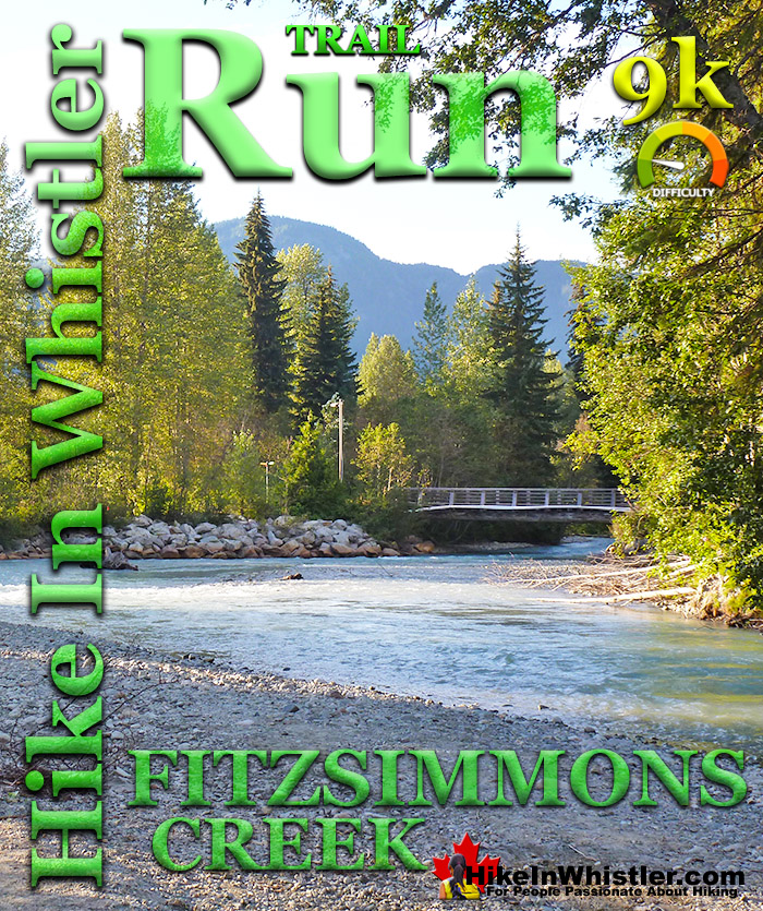
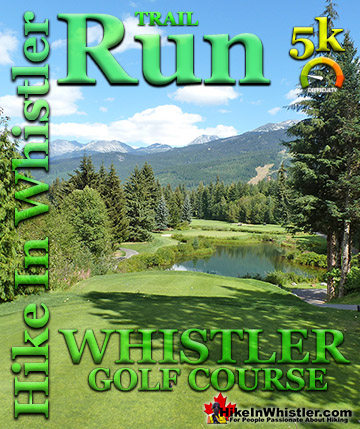
![]() There are plenty of great running trails in Whistler. The Whistler Golf Course 5k is one of the easiest and most convenient. The Blueberry Hill 6k follows part of the same route along Whistler Golf Course, as well as an interesting and challenging section that runs up and over Blueberry Hill. Though only a kilometre longer than the golf course route, the Blueberry Hill 6k has some steep uphill and downhill sections. Much more challenging and rewarding than the golf course run, it requires a bit more routefinding and a couple streets to navigate through. The Whistler Golf Course 5k is easy, relaxing and you don't have to think about where you are going as the route is quite clear. The Lost Lake 6k is similarly easy to follow and quite a bit of nice scenery. As with the Whistler Golf Course 5k and the Blueberry Hill 6k, the Lost Lake 6k starts right from Whistler Village. The trail takes you out and around Lost Lake and back to the Village through an amazingly serene and relaxing forest. The Alta Lake 8k is another beautiful running route that starts and finishes in Whistler Village at the Whistler Golf Course clubhouse. It takes you around Alta Lake, through several beautiful lakeside parks and hardly a minute goes by without a gorgeous mountain, lake or forest view. The Fitzsimmons 9k also begins in Whistler Village and takes you around one side of Lost Lake before continuing out to and across Fitzsimmons Creek, where you then run alongside the river back to where you started in Whistler Village. The Alta Green Lost 15k is a beautiful combination of parts of the previous trails. It takes you from Whistler Village, around Alta Lake along the Alta Lake 8k route. Instead of bending back to Whistler Village, you continue running north, along the River of Golden Dreams until you reach Green Lake. After you run across the amazingly scenic boardwalk bridge across Green Lake, you cross Fitzsimmons Creek and run along the far shore of Lost Lake and back to Whistler Village.
There are plenty of great running trails in Whistler. The Whistler Golf Course 5k is one of the easiest and most convenient. The Blueberry Hill 6k follows part of the same route along Whistler Golf Course, as well as an interesting and challenging section that runs up and over Blueberry Hill. Though only a kilometre longer than the golf course route, the Blueberry Hill 6k has some steep uphill and downhill sections. Much more challenging and rewarding than the golf course run, it requires a bit more routefinding and a couple streets to navigate through. The Whistler Golf Course 5k is easy, relaxing and you don't have to think about where you are going as the route is quite clear. The Lost Lake 6k is similarly easy to follow and quite a bit of nice scenery. As with the Whistler Golf Course 5k and the Blueberry Hill 6k, the Lost Lake 6k starts right from Whistler Village. The trail takes you out and around Lost Lake and back to the Village through an amazingly serene and relaxing forest. The Alta Lake 8k is another beautiful running route that starts and finishes in Whistler Village at the Whistler Golf Course clubhouse. It takes you around Alta Lake, through several beautiful lakeside parks and hardly a minute goes by without a gorgeous mountain, lake or forest view. The Fitzsimmons 9k also begins in Whistler Village and takes you around one side of Lost Lake before continuing out to and across Fitzsimmons Creek, where you then run alongside the river back to where you started in Whistler Village. The Alta Green Lost 15k is a beautiful combination of parts of the previous trails. It takes you from Whistler Village, around Alta Lake along the Alta Lake 8k route. Instead of bending back to Whistler Village, you continue running north, along the River of Golden Dreams until you reach Green Lake. After you run across the amazingly scenic boardwalk bridge across Green Lake, you cross Fitzsimmons Creek and run along the far shore of Lost Lake and back to Whistler Village.
Whistler's Best Running Trails!
Whistler & Garibaldi Park Best Hiking by Month!


Explore BC Hiking Destinations!

Whistler Hiking Trails

Squamish Hiking Trails

Vancouver Hiking Trails

Clayoquot Hiking Trails
Victoria Hiking Trails

