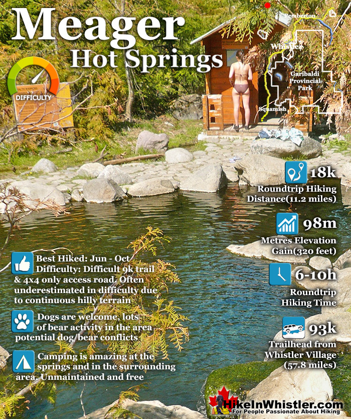
![]() Meager Hot Springs(aka: Meager Creek Hot Springs) is located 93 kilometres northwest of Whistler, was beautifully developed into gorgeous pools, with a caretaker and usage charge. At its height of popularity, Meager Hot Springs had 30,000 yearly visitors. Unfortunately, due to two recent massive landslides it seems unlikely to ever officially reopen. Just a decade ago, in 2009, a nice, expensive access bridge was installed.
Meager Hot Springs(aka: Meager Creek Hot Springs) is located 93 kilometres northwest of Whistler, was beautifully developed into gorgeous pools, with a caretaker and usage charge. At its height of popularity, Meager Hot Springs had 30,000 yearly visitors. Unfortunately, due to two recent massive landslides it seems unlikely to ever officially reopen. Just a decade ago, in 2009, a nice, expensive access bridge was installed.
 Amazing large pool & several small pools
- Visible geological history surrounds Meager
- Hard to get to, so few people go there
- Lots of great places for a tent
- Trail looks across to the 2010 slide path
- The main pool is huge
- You will likely have the place to yourself
- Trail goes through a beautiful forest
- Once a busy, pay to use place, now serene!
 Accessible only by a long 9k hike
Whistler & Garibaldi Hiking
![]() Alexander Falls
Alexander Falls ![]() Ancient Cedars
Ancient Cedars ![]() Black Tusk
Black Tusk ![]() Blackcomb Mountain
Blackcomb Mountain ![]() Brandywine Falls
Brandywine Falls ![]() Brandywine Meadows
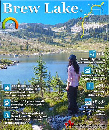
Brandywine Meadows ![]() Brew Lake
Brew Lake ![]() Callaghan Lake
Callaghan Lake ![]() Cheakamus Lake
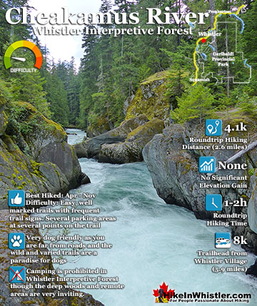
Cheakamus Lake ![]() Cheakamus River
Cheakamus River ![]() Cirque Lake
Cirque Lake ![]() Flank Trail
Flank Trail ![]() Garibaldi Lake
Garibaldi Lake ![]() Garibaldi Park
Garibaldi Park ![]() Helm Creek
Helm Creek ![]() Jane Lakes
Jane Lakes ![]() Joffre Lakes
Joffre Lakes ![]() Keyhole Hot Springs
Keyhole Hot Springs ![]() Logger’s Lake
Logger’s Lake ![]() Madeley Lake
Madeley Lake ![]() Meager Hot Springs
Meager Hot Springs ![]() Nairn Falls
Nairn Falls ![]() Newt Lake
Newt Lake ![]() Panorama Ridge
Panorama Ridge ![]() Parkhurst Ghost Town
Parkhurst Ghost Town ![]() Rainbow Falls
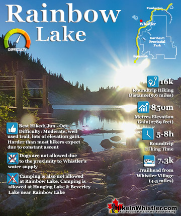
Rainbow Falls ![]() Rainbow Lake
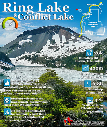
Rainbow Lake ![]() Ring Lake
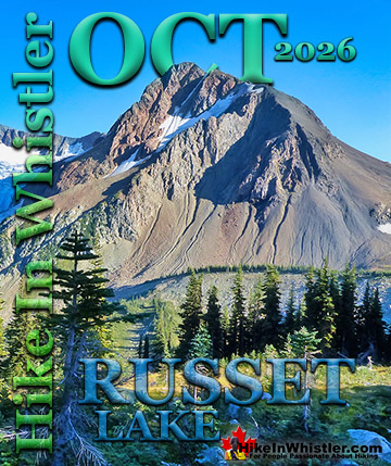
Ring Lake ![]() Russet Lake
Russet Lake ![]() Sea to Sky Trail
Sea to Sky Trail ![]() Skookumchuck Hot Springs
Skookumchuck Hot Springs ![]() Sloquet Hot Springs
Sloquet Hot Springs ![]() Sproatt East
Sproatt East ![]() Sproatt West
Sproatt West ![]() Taylor Meadows
Taylor Meadows ![]() Train Wreck
Train Wreck ![]() Wedgemount Lake
Wedgemount Lake ![]() Whistler Mountain
Whistler Mountain
![]() January
January ![]() February
February ![]() March
March ![]() April
April ![]() May
May ![]() June
June ![]() July
July ![]() August
August ![]() September
September ![]() October
October ![]() November
November ![]() December
December
A few months later it was dramatically obliterated from another slide in 2010. In 2014 the new VOC Harrison Hut Trail was mostly completed, allowing access to Meager Hot Springs once again. Currently this access road is in a bit of a construction zone, so don't be surprised if the road is blocked by a rock slide or road construction. The old access bridge over the Upper Lillooet River which cost nearly a million dollars was wrecked in seconds in 2010. There was considerable wrangling and negotiating to get it built in in 2009, but now it will almost certainly never be rebuilt. The area is far too active. Access to the springs is now via the Harrison Trail via the south side of Upper Lillooet River, above and beyond the still visible, still awe inspiring, mudslide carnage. With the catastrophic mud and debris slide let loose from Devastator Peak in 2010, the nice new (in 2009) million dollar bridge to the Meager Creek Hot Springs was destroyed. Though destroyed doesn't even begin to describe it. Looking on the now, dead end road, where the bridge once stood, the place still looks a mess. "Meager Creek FSR is closed indefinitely; no access to the hot springs." This is from the BCParks Upper Lillooet Provincial Park site, and evidently quite accurate. In the last couple years BC Ministry of Forests and Recreation Sites and Trails BC have been aggressively blocking public access to both Meager Hot Springs and Keyhole Hot Springs. Currently, in 2023 they have blocked both access roads with gates to the trailheads and are threatening to issue violation tickets. The warning reads: SITE CLOSED: Meager Hot Springs are within Lil̓wat Nation territory. This is a place of cultural and spiritual significance for Lil̓wat Nation. The site closure supports the protection of important cultural, environmental, and wildlife values. The Meager Creek Drainage is prone to extremely large landslides, avalanches, and flooding/washouts. The Province will be enforcing this closure and will issue violation tickets to anyone caught ignoring the restrictions. They don't appear to have any legitimate reasons for the closures and are clearly making up vague things to justify blocking public access. For example: "Mineral licks at the hot springs provide wildlife with year-round nutrients. The hot springs are also home to the vivid dancer damselfly, a species of special concern that is threatened by intensive recreational use. Meager Creek Hot Springs is the only known location within BC where the American bulrush (Schoenoplectus americanus) grows".
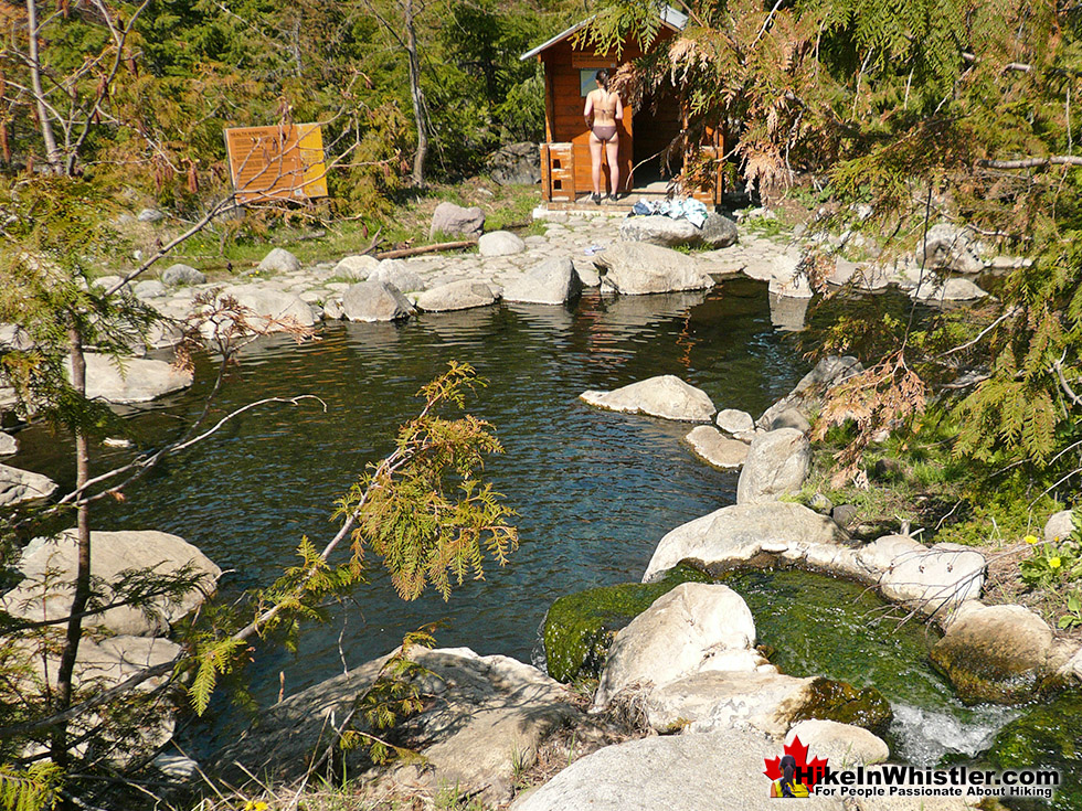
Amazing Main Pool at Meager Hot Springs

Tiny Waterfall of Hot Water Feeds the Pool


Debris Field from the Big Slide
Dead and still dying grey ghosts of trees still stand as they did in piles of forest wreckage. Even the road in looks bizarre. The road was simply bulldozed back to life. On either side, hemmed in by piles of dirt and dead trees. The mudslide that did this seems beyond belief. This river valley in the midst of a beautiful, green forest, became, in an instant, a sea of brown mud, dirt, and dead trees. The landscape across the river in the debris field is hypnotizing. Every inch is mangled and wrecked looking. Twisted trees, extraordinary looking rocks.. and nothing is where it looks like it should be. Both river and creek are fairly shallow, even during the spring runoff. But then again the Upper Lillooet River has only had a couple years to erode back into a conventional river through the debris field. If you are into adventure Meager is still an option, but the whole access route is fraught with peril from another all-to-possible mudslide or trouble at one of the river crossings. The Meager Creek area in general and Mt Meager in particular is an extraordinarily active area under the ground. There have been massively destructive landslides and the inevitable debris flows that follow in 1931, 1947, 1975, 1986 as well as the brutally enormous one in 2010. Four geologists were never found after being killed in the 1975 debris flow.
Meager Slide Debris Field Aerial View in 2014

Meager Slide Debris Field in 2013

Meager Slide Debris Field in 2013

Meager Slide Debris Field Aerial View in 2014

Meager Landslide Carnage in 2013

The Location of the Bridge to Meager in 2012

The Bridge to Meager Before and After the 2010 Slide

At its peak of popularity in 1994, Meager Creek Hot Springs had 30,000 visitors a year. With the unrestrained numbers, vandalism and violence broke out at the springs often so the BC Forest Service stepped in. They hired an on-site supervisor, limited vehicle access and charged a usage fee. Then the big slide of 2010 happened and now of course it only gets a few, very motivated visitors.
The Meager Hot Springs Trail
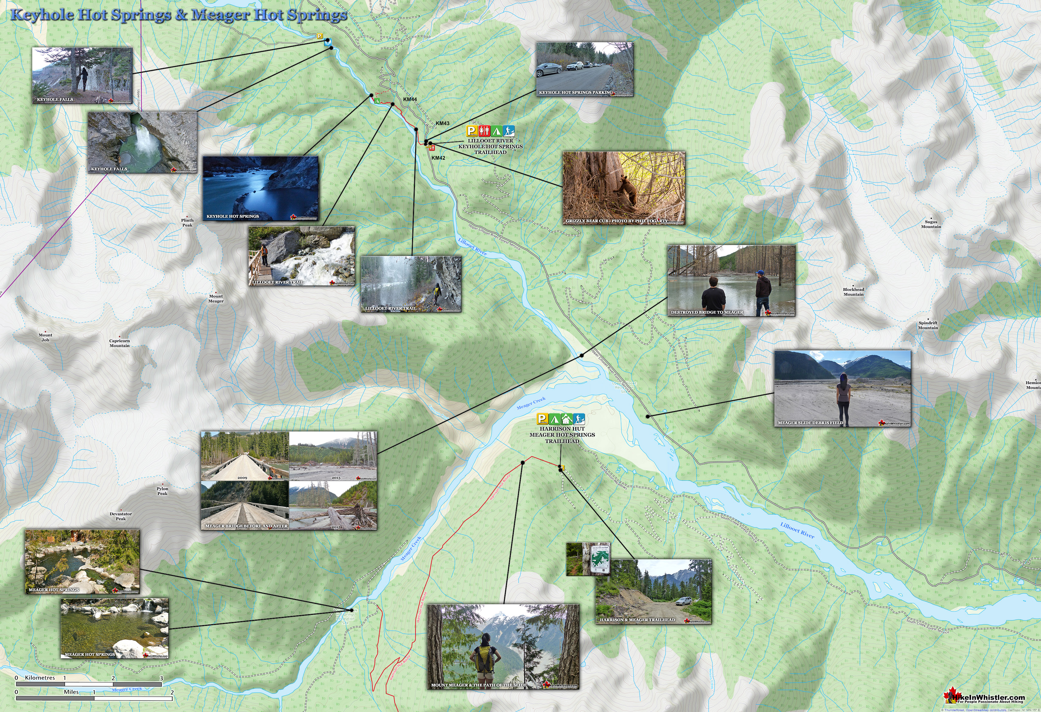
![]() In 2014 a new route was built to Meager Creek Hot Springs by the UBC Varsity Outdoor Club. The new VOC Harrison Hut Trail regains access to the much prized Harrison Hut, but also opens up an excellent access trail to Meager. The trail is long and not too easy, however, and getting to the trailhead is quite an adventure. The logging road deteriorates quickly on the last couple kilometres and you find yourself dodging basketball sized boulders strewn across the road. The old access route to Meager ran along the far(north side) of the Lillooet Forest Service Rd. This new trailhead is located on the near(left or south) side of the Upper Lillooet River and you simply continue along the Pemberton Meadows Road (almost) until you can't go any further. From the middle of Pemberton to the trailhead is 64 kilometres. The easy to miss trailhead is marked with a small trailhead sign for "VOC Harrison Hut Trail" No mention of Meager Creek Hot Springs on it.
In 2014 a new route was built to Meager Creek Hot Springs by the UBC Varsity Outdoor Club. The new VOC Harrison Hut Trail regains access to the much prized Harrison Hut, but also opens up an excellent access trail to Meager. The trail is long and not too easy, however, and getting to the trailhead is quite an adventure. The logging road deteriorates quickly on the last couple kilometres and you find yourself dodging basketball sized boulders strewn across the road. The old access route to Meager ran along the far(north side) of the Lillooet Forest Service Rd. This new trailhead is located on the near(left or south) side of the Upper Lillooet River and you simply continue along the Pemberton Meadows Road (almost) until you can't go any further. From the middle of Pemberton to the trailhead is 64 kilometres. The easy to miss trailhead is marked with a small trailhead sign for "VOC Harrison Hut Trail" No mention of Meager Creek Hot Springs on it.
The Original, Now Inaccessible Trailhead Parking to Meager Hot Springs

The Harrison Hut and Meager Hot Springs Trailhead

The Wildly Beautiful Trail to Meager Hot Springs

The Beautiful Trail to Meager is Well Marked

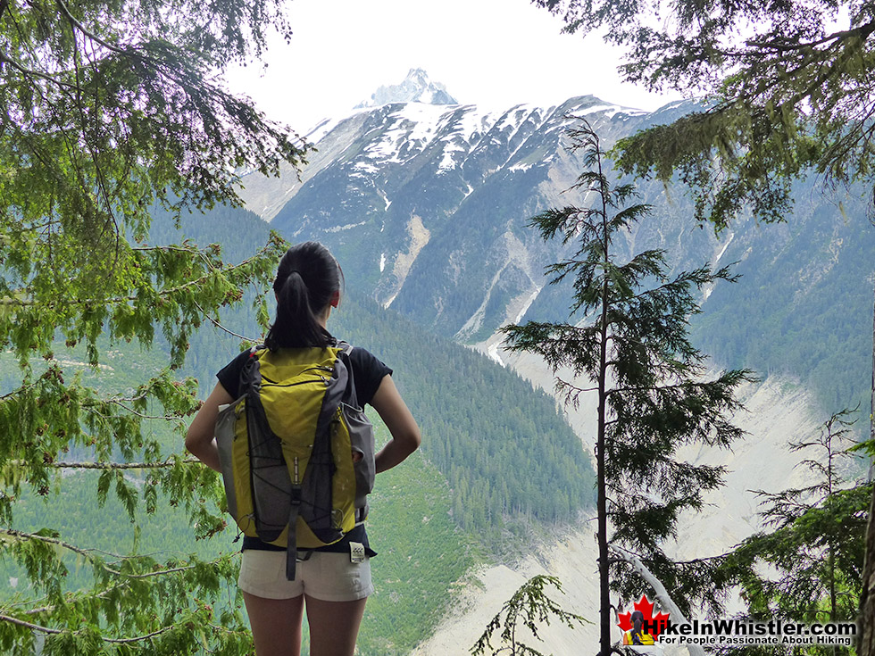
A Zoomed in View of Mount Meager From the Harrison/Meager Trail

The Path of the 2010 Meager Slide

The Meager Viewpoint on the Harrison/Meager Trail

Distant Mount Meager From the Harrison/Meager Trail

The Old Meager Creek Hot Springs Info Board

Welcome to Meager Creek Hot Springs

Meager Creek Hot Springs Sign

The Gorgeous Main Pool at Meager Hot Springs

Meager Hot Springs Main Pool

Trailhead Directions to Meager Hot Springs
![]() Head NW from Pemberton on Pemberton Meadows Road, zero your odometer. The road is beautiful, straight and smooth for a few kilometres before the pavement ends and gravel road begins. A 4x4 is only necessary for the last 4 kilometres to the trailhead. At 60 kilometres the logging road gets very bad and you come to a Y junction, turn left here(the right fork ends 100 metres further at a logging company's locked gate. A gate now blocks access and you have to park here and hike in. Follow this steep and zig-zagging(4x4 only) logging road to the marked trailhead in about 4 kilometres(see the map below). Hike the Harrison Hut trail for 6 kilometres until you come to an old logging road junction on your right. Follow the logging road for 3.5 kilometres down to the hot springs.
Head NW from Pemberton on Pemberton Meadows Road, zero your odometer. The road is beautiful, straight and smooth for a few kilometres before the pavement ends and gravel road begins. A 4x4 is only necessary for the last 4 kilometres to the trailhead. At 60 kilometres the logging road gets very bad and you come to a Y junction, turn left here(the right fork ends 100 metres further at a logging company's locked gate. A gate now blocks access and you have to park here and hike in. Follow this steep and zig-zagging(4x4 only) logging road to the marked trailhead in about 4 kilometres(see the map below). Hike the Harrison Hut trail for 6 kilometres until you come to an old logging road junction on your right. Follow the logging road for 3.5 kilometres down to the hot springs.

Keyhole Hot Springs - Whistler Area Hot Springs
![]() Keyhole Hot Springs (aka Pebble Creek Hot Springs) is located 100 kilometres from Whistler(Village Gate Blvd). Though most of the 100 kilometres is on logging roads, it is driveable by most cars without any trouble. The massive Innergex hydroelectric project has turned this once quiet wilderness into a war-zone. On the plus side, the old logging roads near Keyhole Hot Springs are now well maintained and smooth. The hot springs at Keyhole flow out of the ground adjacent to the swirling, crashing and wonderfully glacier coloured water of the Lillooet River. The colour varies with the season, but for the most part it is a wonderful, deep, milky turquoise. When the sunlight penetrates the deep valley, the milky turquoise changes to an unnaturally bizarre, emerald green colour as it swirls all around you. Sitting in the springs you look across to the vertical rock face and the massive, truck sized chunks of it that lay in the river next to you. Continued here...
Keyhole Hot Springs (aka Pebble Creek Hot Springs) is located 100 kilometres from Whistler(Village Gate Blvd). Though most of the 100 kilometres is on logging roads, it is driveable by most cars without any trouble. The massive Innergex hydroelectric project has turned this once quiet wilderness into a war-zone. On the plus side, the old logging roads near Keyhole Hot Springs are now well maintained and smooth. The hot springs at Keyhole flow out of the ground adjacent to the swirling, crashing and wonderfully glacier coloured water of the Lillooet River. The colour varies with the season, but for the most part it is a wonderful, deep, milky turquoise. When the sunlight penetrates the deep valley, the milky turquoise changes to an unnaturally bizarre, emerald green colour as it swirls all around you. Sitting in the springs you look across to the vertical rock face and the massive, truck sized chunks of it that lay in the river next to you. Continued here...


Skookumchuck Hot Springs - Whistler Area Hot Springs
![]() Skookumchuck Hot Springs, located two hours north of Whistler, and on the way to Sloquet Hot Springs. The name Skookumchuck means "strong water" in the language of the Chinook people of the Pacific Northwest. The name is associated with the hot springs because of the nearby First Nation community of Skatin, which was once called Skookumchuck. The Skookumchuck Hot Springs were also once known as St. Agnes Well during the days of the Fraser Canyon Gold Rush, but that name has fallen into disuse. They are also known locally by the Skatin name as the T'sek Hot Springs. The hot springs start in a pool which is far to hot to use so there are a network of tubes emanating from this pool to feed a ramshackle array of tubs. There are five tubs, which include one very large one under an A-frame which could hold 10 people and is beautifully comfortable. A smaller one under a half A-frame privacy screen which could hold 8 under the stars. And three more open tubs. Clothing, you will quickly discover, is optional. Continued here...
Skookumchuck Hot Springs, located two hours north of Whistler, and on the way to Sloquet Hot Springs. The name Skookumchuck means "strong water" in the language of the Chinook people of the Pacific Northwest. The name is associated with the hot springs because of the nearby First Nation community of Skatin, which was once called Skookumchuck. The Skookumchuck Hot Springs were also once known as St. Agnes Well during the days of the Fraser Canyon Gold Rush, but that name has fallen into disuse. They are also known locally by the Skatin name as the T'sek Hot Springs. The hot springs start in a pool which is far to hot to use so there are a network of tubes emanating from this pool to feed a ramshackle array of tubs. There are five tubs, which include one very large one under an A-frame which could hold 10 people and is beautifully comfortable. A smaller one under a half A-frame privacy screen which could hold 8 under the stars. And three more open tubs. Clothing, you will quickly discover, is optional. Continued here...


Sloquet Hot Springs - Whistler Area Hot Springs
![]() Sloquet Hot Springs is a wonderfully wild set of shallow, man-made pools fed by a small, all natural, and very hot, waterfall. The pools stretch from the waterfall to the large and crashing Sloquet River. The large, spread out campsite for the hot springs lies a short 5 minute walk from the springs. You have to follow a dark and quickly descending trail toward the crashing river. As you near, you can smell the unusual, but kind of nice hot springs scent, and you see steam rising all around you, some steam rising, bizarrely, out of the grass clearing on the edge of the river. On your left a rising cliff, on your right the crashing river. The path narrows and steepens, leading to a large fallen tree which the trail seems to run to. So huge though as to not worry you walking the length of. Then, there it is. The massive fallen tree flanks it. Nestled between the tree and a cliff, in a large triangular area, with the river forming the third side are the Sloquet Hot Springs. Continued here...
Sloquet Hot Springs is a wonderfully wild set of shallow, man-made pools fed by a small, all natural, and very hot, waterfall. The pools stretch from the waterfall to the large and crashing Sloquet River. The large, spread out campsite for the hot springs lies a short 5 minute walk from the springs. You have to follow a dark and quickly descending trail toward the crashing river. As you near, you can smell the unusual, but kind of nice hot springs scent, and you see steam rising all around you, some steam rising, bizarrely, out of the grass clearing on the edge of the river. On your left a rising cliff, on your right the crashing river. The path narrows and steepens, leading to a large fallen tree which the trail seems to run to. So huge though as to not worry you walking the length of. Then, there it is. The massive fallen tree flanks it. Nestled between the tree and a cliff, in a large triangular area, with the river forming the third side are the Sloquet Hot Springs. Continued here...


Whistler's Best Hiking Trails!
Whistler & Garibaldi Park Best Hiking by Month!


Explore BC Hiking Destinations!

Whistler Hiking Trails

Squamish Hiking Trails

Vancouver Hiking Trails

Clayoquot Hiking Trails
Victoria Hiking Trails

