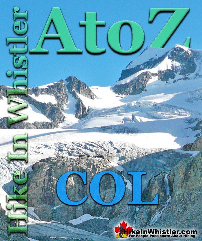
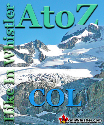
Col: a ridge between two higher peaks, a mountain pass or saddle. More specifically is the lowest point on a mountain ridge between two peaks. Sometimes called a saddle or notch. The Wedge-Weart Col is a popular destination at the top of Wedgemount Glacier. The Wedge-Weart Col connects these two highest peaks in Garibaldi Provincial Park and is easily visible from much of the area around Wedgemount Lake.
One of the defining features of Garibaldi Park, and Wedgemount Lake in particular, is the staggering number of branching hikes from the main destination of the lake itself. For many, Wedgemount Lake and the Wedge Hut is the base for hikes to Wedge Mountain, Mount Cook, Mount Weart, Mount Moe, Mount James Turner and Mount Currie in Pemberton, crossing glaciers such as Wedgemount Glacier, Weart Glacier, Armchair Glacier, Mystery Glacier and the Needles and Chaos Glacier to name a few. Wedgemount Lake itself is a magnificent destination for a day hike or spectacular overnight beneath the dazzling mountain peaks and stars. Many sleep under the stars on one of the many beautiful tent platforms that dot the landscape. Solidly built, wooden tent platforms are everywhere you look at Wedgemount Lake. Strategically positioned, these platforms manage to maintain an amazingly secluded feel despite their numbers. In all Wedgemount Lake has 20 of these tent areas. Most are wooden, but several down by the lake shore are gravel, yet every bit as nice. At a fast hiking pace you can reach Wedgemount Lake from the trailhead in just an hour and a half but at a leisurely or backpack laden pace you will likely take over two hours. The trail is well marked and well used. The steepness of the trail doesn't require any technical skill, however that last kilometre before the lake you will be scrambling on all fours quite a bit.
More Whistler & Garibaldi Park Hiking A to Z!
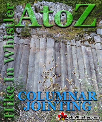
Columnar Jointing: bizarre looking columns of oddly angular rock formations that can be found in many places around Whistler and worldwide. Generally ...
Col: a ridge between two higher peaks, a mountain pass or saddle. More specifically is the lowest point on a mountain ridge between two peaks. Sometimes ...
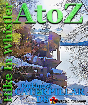
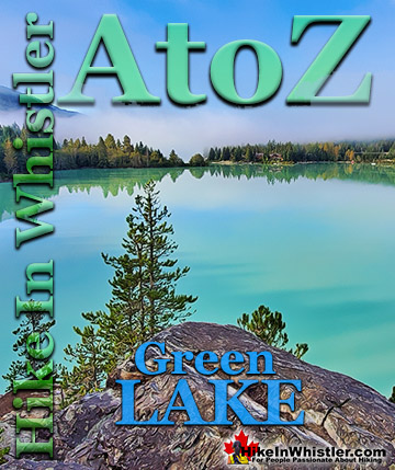
Along the shore of Green Lake, you will find a monstrous old Caterpillar tractor that dates from the 1930’s. Abandoned here in the 1950’s, it looks as if the ...
Green Lake is the marvellously vivid, green coloured lake just north of Whistler Village. Driving north on the Sea to Sky Highway, Green Lake appears ...
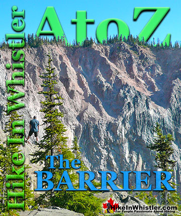
The Barrier formed as a result of huge lava flows from Clinker Peak on the west shoulder of Mount Price during the last ice age. About thirteen thousand ...
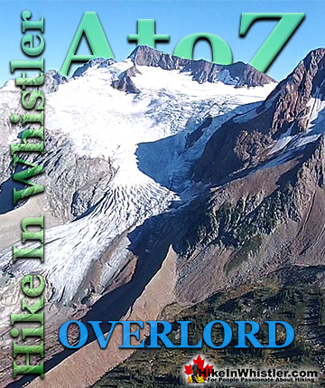
Overlord Mountain is the highest peak in the Fitzsimmons Range. Overlord is surrounded by several mountains that collectively are named the Overlord ...
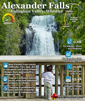
Alexander Falls is a very impressive 43 metre/141 foot waterfall just 30 to 40 minutes south of Whistler in the Callaghan Valley. Open year-round and located just before Whistler Olympic Park where several ...
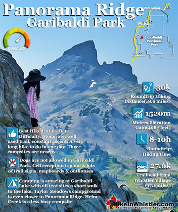
Panorama Ridge is easily one of the most amazing hikes in Garibaldi Provincial Park. The 15 kilometre(9.3 mile) hike from the trailhead at Rubble Creek to Panorama Ridge takes you through beautiful and deep ...
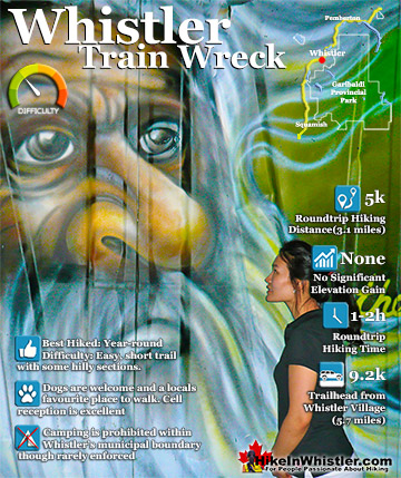
The trail to Whistler Train Wreck is an easy, yet varied route through deep forest, across a great suspension bridge over Cheakamus River, to a stunning array of wrecked train cars. The trail from your car to ...
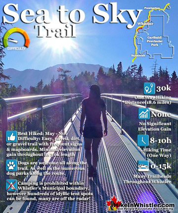
The Sea to Sky Trail is a 180 kilometre multi-use trail that runs from Squamish to D'Arcy. The trail is still under construction in many parts, however, the amazing route through Whistler is finally in ...
July is a wonderful time to hike in Whistler and Garibaldi Provincial Park. The weather is beautiful and the snow on high elevation hiking trails is long ...
August hiking in Whistler definitely has the most consistently great, hot weather. You can feel the rare pleasure of walking across a glacier shirtless and ...
September hiking in Whistler is possibly the best month of all. The snow has melted far up to the mountain tops, yet the temperatures are still quite ...
Hiking in Whistler in October is often unexpectedly stunning. The days are much shorter and colder but the mountains are alive with colour from the fall ...
Hiking in Whistler is spectacular and wonderfully varied. Looking at a map of Whistler you see an extraordinary spider web of hiking trails that are unbelievably numerous. Easy trails, moderate trails and challenging hiking trails are all available. Another marvellous ...
Squamish is located in the midst of a staggering array of amazing hiking trails. Garibaldi Provincial Park sprawls alongside Squamish and up and beyond Whistler. Tantalus Provincial Park lays across the valley to the west and the wonderfully remote Callaghan Valley ...
Vancouver is surrounded by seemingly endless hiking trails and mountains to explore. Massive parks line up one after another. Mount Seymour Provincial Park, Lynn Canyon Park, Grouse Mountain, Cypress Park and the enormous Garibaldi Park all contribute to Vancouver ...
Clayoquot Sound has a staggering array of hiking trails within it. Between Tofino and Ucluelet, Pacific Rim Park has several wilderness and beach trails, each one radically different from the last. The islands in the area are often Provincial parks on their own with ...
Victoria has a seemingly endless number of amazing hiking trails. Most take you to wild and beautiful Pacific Ocean views and others take you to tranquil lakes in beautiful BC Coastal Rainforest wilderness. Regional Parks and Provincial Parks are everywhere you turn ...
The West Coast Trail was created after decades of brutal and costly shipwrecks occurred along the West Coast of Vancouver Island. One shipwreck in particular was so horrific, tragic and unbelievable that it forced the creation of a trail along the coast, which ...