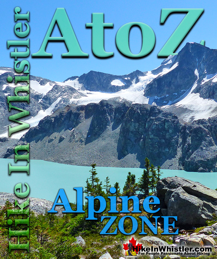
![]() Alpine Zone or Alpine Tundra is the area above the treeline, often characterized by stunted, sparse forests of krummholz and pristine, turquoise lakes. Mount Sproatt is an excellent example of an alpine zone in Whistler. Dozens of alpine lakes, rugged and rocky terrain and hardy krummholz trees everywhere you look. The hostile, cold and windy climate in the alpine zones around Whistler make tree growth difficult. Added to that, the alpine areas are snow covered the majority of the year.
Alpine Zone or Alpine Tundra is the area above the treeline, often characterized by stunted, sparse forests of krummholz and pristine, turquoise lakes. Mount Sproatt is an excellent example of an alpine zone in Whistler. Dozens of alpine lakes, rugged and rocky terrain and hardy krummholz trees everywhere you look. The hostile, cold and windy climate in the alpine zones around Whistler make tree growth difficult. Added to that, the alpine areas are snow covered the majority of the year.
Whistler & Garibaldi Hiking
![]() Alexander Falls
Alexander Falls ![]() Ancient Cedars
Ancient Cedars ![]() Black Tusk
Black Tusk ![]() Blackcomb Mountain
Blackcomb Mountain ![]() Brandywine Falls
Brandywine Falls ![]() Brandywine Meadows
Brandywine Meadows ![]() Brew Lake
Brew Lake ![]() Callaghan Lake
Callaghan Lake ![]() Cheakamus Lake
Cheakamus Lake ![]() Cheakamus River
Cheakamus River ![]() Cirque Lake
Cirque Lake ![]() Flank Trail
Flank Trail ![]() Garibaldi Lake
Garibaldi Lake ![]() Garibaldi Park
Garibaldi Park ![]() Helm Creek
Helm Creek ![]() Jane Lakes
Jane Lakes ![]() Joffre Lakes
Joffre Lakes ![]() Keyhole Hot Springs
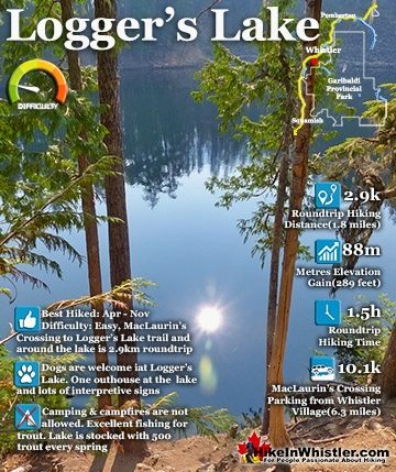
Keyhole Hot Springs ![]() Logger’s Lake
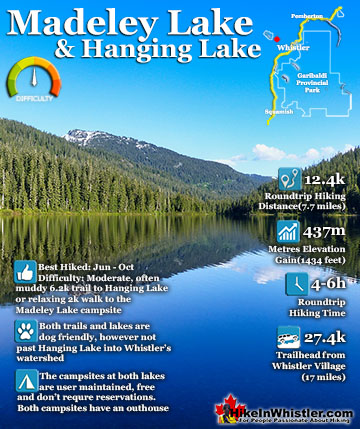
Logger’s Lake ![]() Madeley Lake
Madeley Lake ![]() Meager Hot Springs
Meager Hot Springs ![]() Nairn Falls
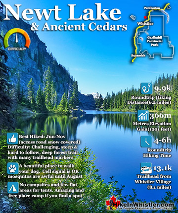
Nairn Falls ![]() Newt Lake
Newt Lake ![]() Panorama Ridge
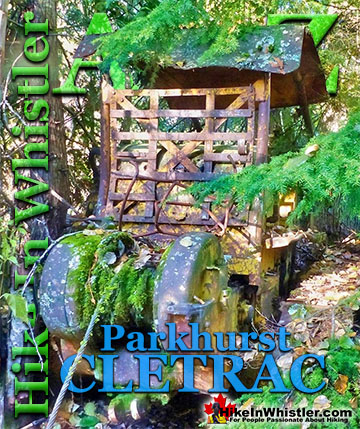
Panorama Ridge ![]() Parkhurst Ghost Town
Parkhurst Ghost Town ![]() Rainbow Falls
Rainbow Falls ![]() Rainbow Lake
Rainbow Lake ![]() Ring Lake
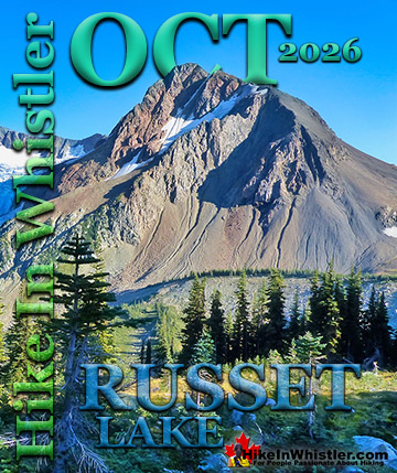
Ring Lake ![]() Russet Lake
Russet Lake ![]() Sea to Sky Trail
Sea to Sky Trail ![]() Skookumchuck Hot Springs
Skookumchuck Hot Springs ![]() Sloquet Hot Springs
Sloquet Hot Springs ![]() Sproatt East
Sproatt East ![]() Sproatt West
Sproatt West ![]() Taylor Meadows
Taylor Meadows ![]() Train Wreck
Train Wreck ![]() Wedgemount Lake
Wedgemount Lake ![]() Whistler Mountain
Whistler Mountain
![]() January
January ![]() February
February ![]() March
March ![]() April
April ![]() May
May ![]() June
June ![]() July
July ![]() August
August ![]() September
September ![]() October
October ![]() November
November ![]() December
December
Other good places to explore alpine zones in Whistler and Garibaldi Park are Wedgemount Lake, Blackcomb Mountain, Whistler Mountain, Black Tusk, Brandywine Meadows, Brew Lake, Callaghan Lake Provincial Park, and quite a lot more. Located within sight of Whistler Village, Wedge Mountain is the highest mountain in Garibaldi Provincial Park. Just a relatively short, 7 kilometre hike takes you to this mountain paradise of impossibly turquoise water and jagged mountain peaks all around. The shortness of the hike to Wedgemount Lake lulls hikers into thinking it is an easy trail. The elevation gain, however is a staggering 1220 metres in this short distance. If you are very fit and unburdened with a heavy backpack, you may get to the lake in 1.5 hours. If you are carrying gear, however, you can easily double this time. The Wedgemount Lake trail is easy to follow and well marked, but it follows a constant and unrelenting, steep ascent to the end. If you pack light, you will often pass a few hikers who didn't. The tough trail makes arriving at this paradise in the mountains very rewarding and shows you a great example of an alpine zone in Whistler.


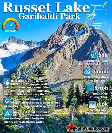
Russet Lake Alpine Zone
The image shown here(below) is the alpine zone around Russet Lake in Garibaldi Provincial Park. The Fissile towers above Russet Lake in the alpine paradise which lays at the head of the valley that separates Whistler and Blackcomb mountains and emerges in Whistler Village. Fitzsimmons Creek, the beautiful turquoise, glacier coloured creek that flows through Whistler Village is fed by Overlord Glacier on the far left and Russet Lake on the right.


Whistler Mountain Alpine Zone
Whistler Mountain's Peak Chair is shown here(below) with the marvellous alpine zone of Blackcomb Mountain in the Spearhead Range in the background. The Peak Chair is a wonderful, carnival-like ride to the summit of Whistler Mountain and a vast network of hiking trails. The High Note trail starts here and takes you over the Musical Bumps to Russet Lake. From Russet Lake you can take the Singing Pass trail which takes you down the valley along Fitzsimmons Creek, all the way to Whistler Village. The Singing Pass trail emerges at the base of Whistler Mountain near the Dubh Linn Gate Pub.


Garibaldi Provincial Park Alpine Zones
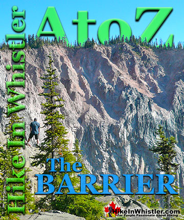
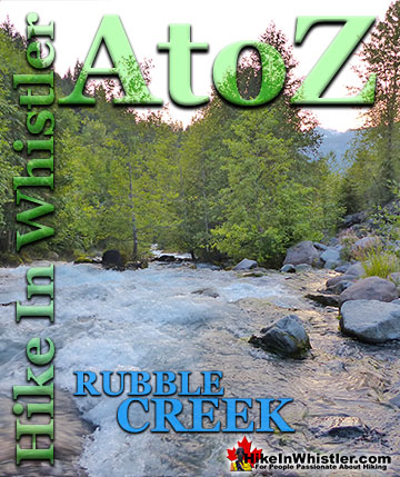
The alpine zone around Black Tusk is magnificent. This image(below) is the view from the summit, with Mount Garibaldi dominating the skyline, The Table below it, and Mount Price to the right of The Table. Clinker Peak is the far right peak of Mount Price, which is the huge mountain that rises from the shore of Garibaldi Lake. Clinker Peak was an active volcano during the last ice age and you can still easily see the lava flows heading off to the right, around the end of Garibaldi Lake and the Battleship Islands. About 9000 years ago the lava flowed down the valley and was blocked by the enormous glacier that filled Cheakamus Valley. The lava pooled and rapidly cooled, forming an enormous vertical rock wall that remained when the glacier retreated north. This gigantic barrier allowed Garibaldi Lake to form, where previously it was a valley that connected to the much larger Cheakamus Valley. The Barrier remains today, however it is comprised of pretty unstable and crumbling rock. It is prone to enormous collapses from time to time. The last major collapse was in the winter of 1855/1856, when more than 25 million cubic metres of rock tumbled 6 kilometres down the valley at over 30 metres per second. Today, you can see plenty of evidence of this huge landslide along Rubble Creek and on either side of the Sea to Sky Highway along Cheakamus River near Daisy Lake.


Brandywine Meadows Alpine Zone
Brandywine Meadows is an absolute paradise on a sunny, summer day. The valley is filled with colour, from the green forest, to the bright flowers and up to the glistening, snowy cliffs. There are even plenty of enormous erratics left by glaciers thousands of years ago and warmed by the sun, make spectacular places to relax on. Wandering up the valley towards Brandywine Mountain gives you a great view, looking back, of this beautiful alpine zone so close to Whistler. Brandywine Meadows is one of the many spectacular places you can camp for free around Whistler. No-trace camping is not as hard to find as you might expect in Whistler, unlike the overcrowded campsites in Garibaldi Provincial Park.


Cirque Lake Alpine Zone
Cirque Lake, shown here(below) is another alpine paradise in Whistler. Hidden up above Callaghan Lake in the wild and beautiful Callaghan Valley, Cirque Lake has a short, but very steep hiking trail to reach this amazing spot. Cirque Lake gets it name from the wonderful phenomenon of geology where a glacier gouges out a depression to form a lake. Not only is Cirque Lake symmetrically stunning, but the walls of the cirque partly shelter you from the wind, making this alpine zone warmer than you would expect on a typically windy day in the mountains.


Mount Sproatt Alpine Zone
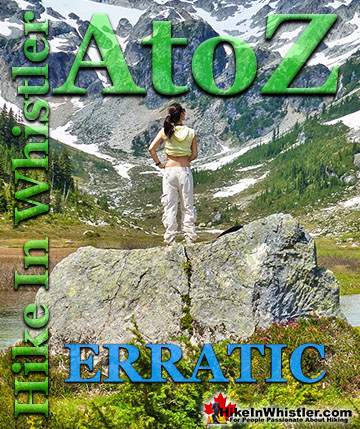
Another beautiful alpine paradise in Whistler is Mount Sproatt. The recently built, and still expanding hiking and biking trail network on Sproatt covers a staggering area and opens up access that was previously following vague routes or difficult bushwhacking. Shown below is one of many idyllic tent spots in this beautifully sprawling alpine zone, high above Whistler. Mount Sproatt, or as it is known locally as simply "Sproatt", is one of the many towering mountains visible from Whistler Village. Above and beyond Alta Lake, directly across from Whistler Mountain and Blackcomb Mountain. Next time you walk through Whistler Village and cross the pedestrian bridge (with Village Gate Boulevard below you), you will see Sproatt in the distance. It is the rocky giant, abruptly steep on one end and gently sloping on the other. At its summit you may be able to make out the small weather recording structure. What you can't see from Whistler Village is the extraordinarily beautiful alpine paradise that lays beyond it. Lakes and tarns everywhere you look. Fields of alpine flowers and wonderfully mangled, yet strikingly beautiful forests of krummholz. Hostile looking fields of boulders and absurdly placed erratics the size of RV's. Beyond, of course, endless stunning view of distant, snowy mountains. There are several challenging trails up Sproatt and two main routes stand out, the Sproatt West (Northair) trailhead and the Sproatt East (Stonebridge) trailhead. The Sproatt West trailhead is found a couple kilometres past Northair Mine in Callaghan Valley and you need a 4x4 to get much further than the mine. The Sproatt East trailhead is much closer to Whistler Village and no 4x4 is necessary as the road is paved all the way to the trailhead. Stonebridge is the luxurious neighbourhood nestled on the lower slopes of Sproatt.


Rainbow Lake Alpine Zone
Mount Sproatt dominates the skyline across the valley from Whistler and Blackcomb with another huge mountain, Rainbow Mountain. Rainbow Mountain and Rainbow Lake, shown here below, is one of oldest mountain hiking trails in Whistler. A century ago when just a few dozen people lived in the valley here it was called Alta Lake. Rainbow Lodge was built where Rainbow Park is today and Rainbow Falls became a popular destination for visitors to the lodge. Rainbow Lodge was the focus of much of the activity in the valley along with small scale mining on the mountains, and later logging. The Singing Pass trail also dates to about a century ago, though much of the lower part of the trail used to be on the Blackcomb Mountain side of Fitzsimmons Creek, whereas now it is on the Whistler Mountain side. Though you can't swim in Rainbow Lake or camp near it as it is Whistler's source for water, it has some great views across the valley to Wedge Mountain and Blackcomb Mountain(shown here).


More Whistler & Garibaldi Park Hiking A to Z!

The Best Whistler & Garibaldi Park Hiking Trails!
Whistler & Garibaldi Park Best Hiking by Month!


Explore BC Hiking Destinations!

Whistler Hiking Trails

Squamish Hiking Trails

Vancouver Hiking Trails

Clayoquot Hiking Trails
Victoria Hiking Trails

