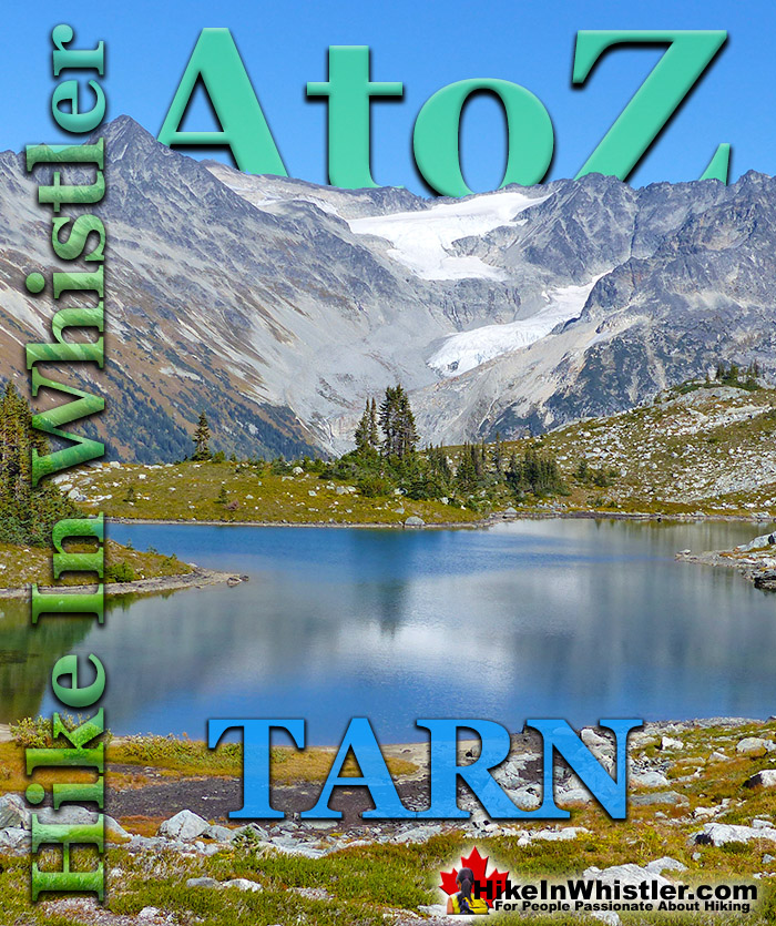
Tarn: a small alpine lake. The word tarn originates from the Norse word tjorn which translates to English as pond. In the United Kingdom, tarn is widely used to refer to any small lake or pond. In British Columbia tarn is used specifically for small mountain lakes. Around Whistler tarns number in the hundreds and many are so small and/or hidden as to remain unnamed. Russet Lake in Garibaldi Provincial Park could be called a tarn, however its relatively large size dominates the area and the term lake seems more appropriate.
Near Russet Lake there are two beautifully characteristic tarns named Adit Lakes. Both lakes are small, shallow and have irregular shapes. The two lakes lay in quite a remarkable setting overlooking the valley separating the Fitzsimmons Range and the Spearhead Range. The image below shows the view across to the Spearhead Range. Tremor Mountain and Mount Macbeth are the two prominent peaks. The upper glacier flows from Tremor Mountain from the left and Quiver Peak and The Ripsaw from the right. The lower glacier is Curtain Glacier which disappears behind Mount Macbeth. Hundreds of tarns can be found in the mountains around Whistler and most are unnamed. Mount Sproatt, across the valley from Whistler Mountain is home to several stunning tarns. Owing to the broad and seemingly endless alpine terrain on Mount Sproatt, there are dozens of tarns. Tarns are by definition quite small and comparatively warm to swim in, unlike the brutally cold Garibaldi Lake, Wedgemount Lake, Cheakamus Lake and Green Lake. Though many hiking trails in Whistler and Garibaldi Park have become crowded in recent years, finding a beautiful tarn in the wilderness around Whistler is actually pretty easy. Having a serene and secluded tarn on top of a mountain all to yourself is pretty amazing.
Finding a perfect paradise in the mountains around Whistler is not too difficult. This serene little tarn is on Mount Sproatt and just one of many found in the vast wilderness up there. The water temperature is far from cold due to the shallowness, only about 3 metres deep in the middle. Mount Sproatt is criss-crossed with several hiking and biking trails, which makes it reasonably accessible. It's vast area, however, makes it easy to find solitude and a perfect waterfront view for your tent.
More Whistler & Garibaldi Park Hiking A to Z!
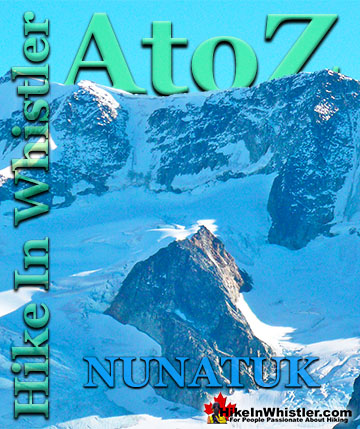
Nunatuk: a rock projection protruding through permanent ice or snow. Their distinct appearance in an otherwise barren landscape often makes them ...
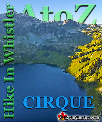
Cirque: a glacier-carved bowl or amphitheater in the mountains. To form, the glacier must be a combination of size, a certain slope and more unexpectedly, a ...
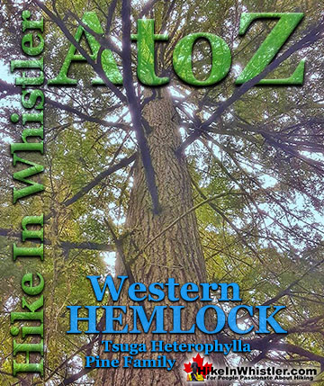
Western hemlock (tsuga heterophylla) is a large evergreen coniferous tree that is native to the west coast of North America. Unlike many other trees in ...
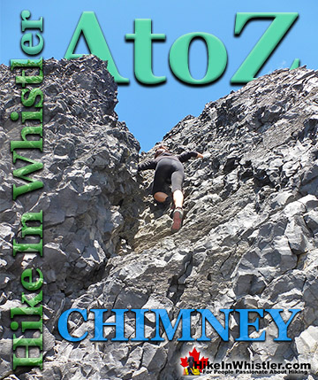
Chimney: a gap between two vertical faces of rock or ice. Often a chimney offers the only viable route to the summit of a mountain. An example of this is Black ...
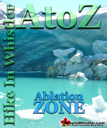
Ablation Zone: the lower altitude region of a glacier where there is a net loss of ice mass due to melting, sublimation, evaporation, ice calving or ...
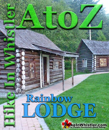
Rainbow Lodge was a popular wilderness lodge in the small community called Alta Lake, and what would eventually be called Whistler It was a fishing and ...
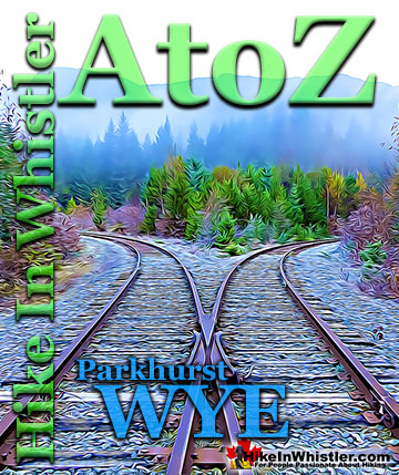
When hiking to Parkhurst Ghost Town, the first area you will encounter after you cross the disintegrating bridge over Wedge Creek is the wye. In railroad ...
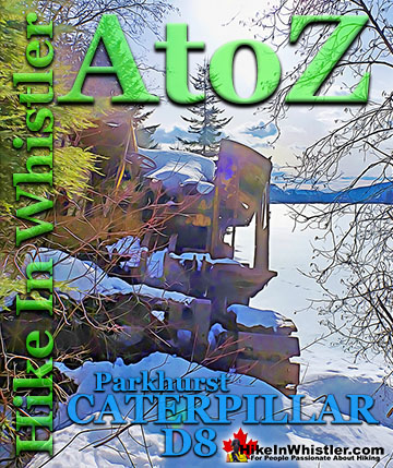
Along the shore of Green Lake, you will find a monstrous old Caterpillar tractor that dates from the 1930’s. Abandoned here in the 1950’s, it looks as if the ...
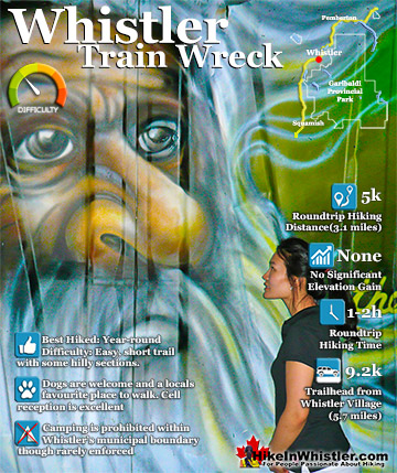
The trail to Whistler Train Wreck is an easy, yet varied route through deep forest, across a great suspension bridge over Cheakamus River, to a stunning array of wrecked train cars. The trail from your car to ...
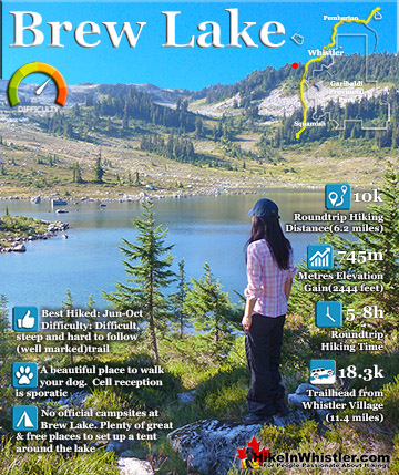
Brew Lake is beautiful mountain lake just a short drive south of Whistler and is relatively unknown and seldom hiked. Laying at the base of Mount Brew, Brew Lake lays in a massive alpine valley of enormous ...
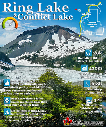
Ring Lake is a fantastically serene and wonderfully remote lake similar to Cirque Lake, but considerably farther to hike to reach it. The 10 kilometre(6.2 mile) hike takes you through a rarely hiked forest, ...
July is a wonderful time to hike in Whistler and Garibaldi Provincial Park. The weather is beautiful and the snow on high elevation hiking trails is long ...
August hiking in Whistler definitely has the most consistently great, hot weather. You can feel the rare pleasure of walking across a glacier shirtless and ...
September hiking in Whistler is possibly the best month of all. The snow has melted far up to the mountain tops, yet the temperatures are still quite ...
Hiking in Whistler in October is often unexpectedly stunning. The days are much shorter and colder but the mountains are alive with colour from the fall ...
Hiking in Whistler is spectacular and wonderfully varied. Looking at a map of Whistler you see an extraordinary spider web of hiking trails that are unbelievably numerous. Easy trails, moderate trails and challenging hiking trails are all available. Another marvellous ...
Squamish is located in the midst of a staggering array of amazing hiking trails. Garibaldi Provincial Park sprawls alongside Squamish and up and beyond Whistler. Tantalus Provincial Park lays across the valley to the west and the wonderfully remote Callaghan Valley ...
Vancouver is surrounded by seemingly endless hiking trails and mountains to explore. Massive parks line up one after another. Mount Seymour Provincial Park, Lynn Canyon Park, Grouse Mountain, Cypress Park and the enormous Garibaldi Park all contribute to Vancouver ...
Clayoquot Sound has a staggering array of hiking trails within it. Between Tofino and Ucluelet, Pacific Rim Park has several wilderness and beach trails, each one radically different from the last. The islands in the area are often Provincial parks on their own with ...
Victoria has a seemingly endless number of amazing hiking trails. Most take you to wild and beautiful Pacific Ocean views and others take you to tranquil lakes in beautiful BC Coastal Rainforest wilderness. Regional Parks and Provincial Parks are everywhere you turn ...
The West Coast Trail was created after decades of brutal and costly shipwrecks occurred along the West Coast of Vancouver Island. One shipwreck in particular was so horrific, tragic and unbelievable that it forced the creation of a trail along the coast, which ...